
Size of this preview: 417 × 599 pixels. Other resolutions: 167 × 240 pixels | 334 × 480 pixels | 535 × 768 pixels | 713 × 1,024 pixels | 2,231 × 3,203 pixels.
Original file (2,231 × 3,203 pixels, file size: 323 KB, MIME type: image/png)
| This is a file from the Wikimedia Commons. Information from its description page there is shown below. Commons is a freely licensed media file repository. You can help. |
Summary
| Description |
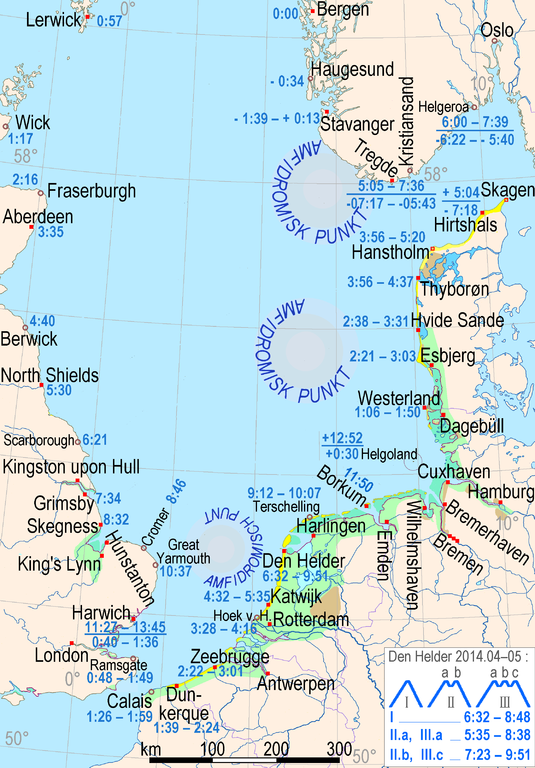
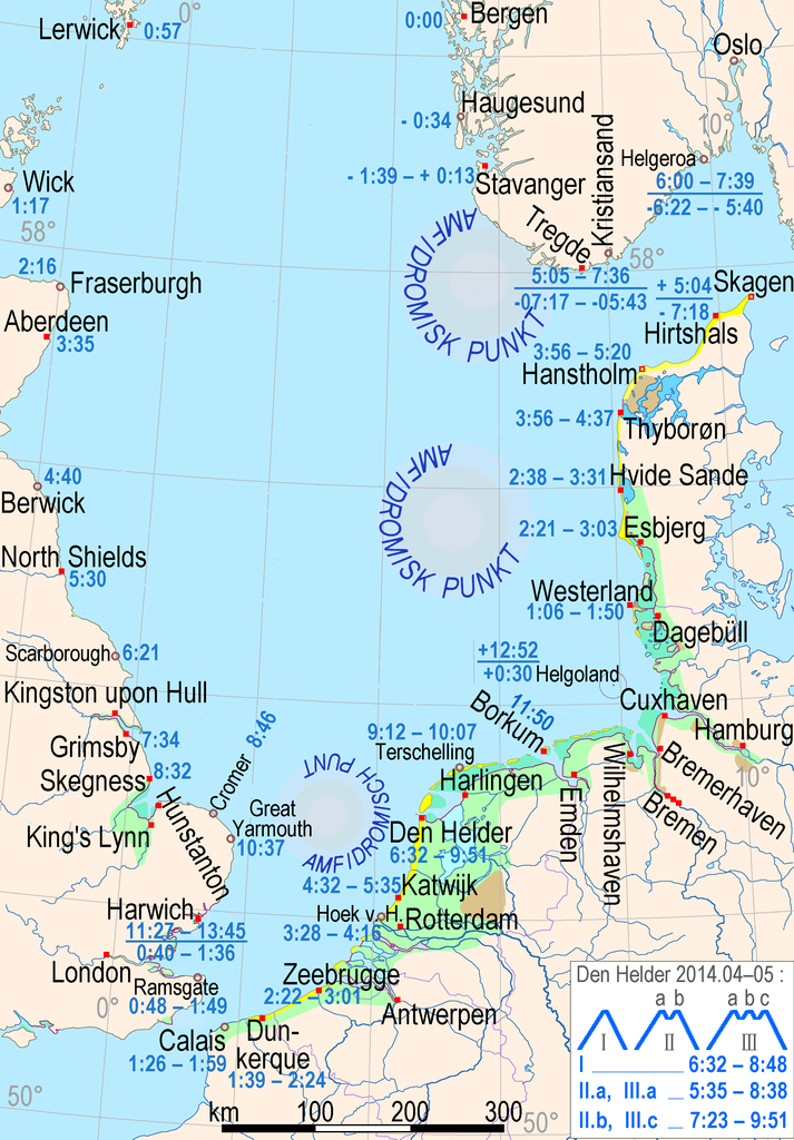
English: Location map for the list of selected tide ranges on southern North Sea, timelines of the tide waves (three synchronous amphidromic circles), coastal marshes (green), mudflats (jade), lagoons (bright blue), dunes (yellow), sea dikes (purple), moraines near the coast (light brown), rock-based coasts (grayish brown)]] Deutsch: Lokalisationskarte für die Liste ausgewählter Tidenhübe an der südlichen Nordsee, Flutstundenlinien der drei synchron rotierenden Tidenwellen, Küstenmarschen grün, Watt blaugrün, Lagunen leuchtend blau, Dünen gelb, Seedeiche purpur, küstennahe Geest hellbraun, Küsten mit felsigem Untergrund (Tertiär und älter) graubraun |
| Date | |
| Source | Own work |
| Author | Ulamm (talk) 23:35, 17 March 2014 (UTC) |
Information used
- Geological Map of Great Britain
- Google maps & streetview
- Geodætisk Institut Danmark, Færdselskort 1:200 000 N°1, 2, 3
- Birger Larsen: Blåvands Huk, Horns Rev området - et nyt Skagen? in De nationale Geologiske Undersøgelser for Danmark og Grønland Nr. 4, 2003 archive copy at the Wayback Machine
- Dennis Anthony & Ingelise Møller The geological architecture and development of Holmsland Barrier and Ringkjøbing Fjord area, Danish North Sea Coast, in Danish Journal of Geography, 2002 (PDF)
- LIAG Schleswig-Holstein: Der Untergrund von Föhr, Kap. 2 mit Abb. 6 (S.15)
- Landesportal SH → Fachpläne Küstenschutz → Historisches zur Insel Sylt
- English Nature → Report Nummber 470, part 1: Centre for Ecology & Hydrology → Littoral sediments of The Wash and Norfolk Coast SAC – The 1998 surveys of intertidal sediment and invertebrates
- Frank Ahnert, Einführung in die Geomorphologie, 4th edition. 2009, Ulmer UTB, ISBN 978-3-8252-8103-8, p. 329, fig. 25.2., from King, C. A. M., Beaches and Coasts, 2nd edition. 1972, St. Martins Press, London
- Norwegian official tide tables
Licensing
I, the copyright holder of this work, hereby publish it under the following license:
This file is licensed under the Creative Commons Attribution-Share Alike 3.0 Unported license.
- You are free:
- to share – to copy, distribute and transmit the work
- to remix – to adapt the work
- Under the following conditions:
- attribution – You must give appropriate credit, provide a link to the license, and indicate if changes were made. You may do so in any reasonable manner, but not in any way that suggests the licensor endorses you or your use.
- share alike – If you remix, transform, or build upon the material, you must distribute your contributions under the same or compatible license as the original.
File history
Click on a date/time to view the file as it appeared at that time.
| Date/Time | Thumbnail | Dimensions | User | Comment | |
|---|---|---|---|---|---|
| current | 11:57, 18 June 2014 | | 2,231 × 3,203 (323 KB) | Kopiersperre | optipng |
| 20:36, 25 April 2014 |  | 2,231 × 3,203 (414 KB) | Ulamm | scale ruler reintegrated | |
| 18:07, 25 April 2014 |  | 2,231 × 3,203 (413 KB) | Ulamm | more realistic presentation of the movement of the tides | |
| 12:16, 20 April 2014 |  | 2,231 × 3,203 (357 KB) | Ulamm | + Skagerrak | |
| 01:04, 20 April 2014 |  | 2,231 × 3,203 (350 KB) | Ulamm | Port of North Shields and dunes of Zeeland | |
| 13:43, 20 March 2014 |  | 2,231 × 3,203 (349 KB) | Ulamm | coastal formations more detailed | |
| 10:53, 20 March 2014 |  | 2,231 × 3,203 (348 KB) | Ulamm | visibility of the isochronic lines of the amphidromic systems | |
| 16:47, 17 March 2014 |  | 2,231 × 3,203 (348 KB) | Ulamm | grid, once more | |
| 16:46, 17 March 2014 |  | 2,231 × 3,203 (347 KB) | Ulamm | grid | |
| 16:29, 17 March 2014 |  | 2,231 × 3,203 (347 KB) | Ulamm | + Aberdeen |
File usage
The following pages on the English Wikipedia use this file (pages on other projects are not listed):
Global file usage
The following other wikis use this file:
- Usage on de.wikipedia.org
- Usage on hr.wikipedia.org
- Usage on hu.wikipedia.org