The_Hermitage,_Warkworth_-_geograph.org.uk_-_735173.jpg (640 × 426 pixels, file size: 98 KB, MIME type: image/jpeg)
| This is a file from the Wikimedia Commons. Information from its description page there is shown below. Commons is a freely licensed media file repository. You can help. |
Summary
| Description |
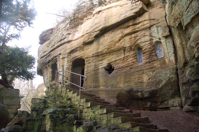
English: The Hermitage, Warkworth From Wikipedia
Warkworth Hermitage is an unusual relic situated on the North bank of the River Coquet in Northumberland, England, close to the village of Warkworth. The Hermitage consists of an outer portion built of stone, and an inner portion hewn from the steep rock above the river. This inner part comprises a chapel and a smaller chamber, both having altars. There is an altar-tomb with a female effigy in the chapel. From the window between the inner chamber and the chapel, and from other details, the date of the work may be placed in the latter part of the 14th century, the characteristics being late Decorated. The traditional story of the origin of the hermitage, attributing it to one of the Bertrams of Bothal Castle in this county, is told in Bishop Percy's ballad The Hermit of Warkworth (1771). The carving in the window is a nativity scene, the female is Mary with the new born child at her breast; the item at her feet is the head of a bull, and the figure at her shoulder is an angel. Of the dedication crosses placed at the time of its construction only one is visible, the alter was plain the crafety is just that. The ballad is to all intents fiction as the chapel was built as a chantry, and occupied by a series of clergy from 1489 to 1536; since that time it has remained as it is today. |
| Date | |
| Source | From geograph.org.uk |
| Author | hayley green |
| Attribution (required by the license) | hayley green / The Hermitage, Warkworth / |
| Camera location | | View this and other nearby images on: OpenStreetMap |
|---|
_heading:90.00&language=en)
| Object location | | View this and other nearby images on: OpenStreetMap |
|---|
_heading:90.00&language=en)
Licensing

|
This image was taken from the Geograph project collection. See this photograph's page on the Geograph website for the photographer's contact details. The copyright on this image is owned by hayley green and is licensed for reuse under the Creative Commons Attribution-ShareAlike 2.0 license.
|
- You are free:
- to share – to copy, distribute and transmit the work
- to remix – to adapt the work
- Under the following conditions:
- attribution – You must give appropriate credit, provide a link to the license, and indicate if changes were made. You may do so in any reasonable manner, but not in any way that suggests the licensor endorses you or your use.
- share alike – If you remix, transform, or build upon the material, you must distribute your contributions under the same or compatible license as the original.
File history
Click on a date/time to view the file as it appeared at that time.
| Date/Time | Thumbnail | Dimensions | User | Comment | |
|---|---|---|---|---|---|
| current | 09:21, 19 February 2011 | | 640 × 426 (98 KB) | GeographBot | == {{int:filedesc}} == {{Information |description={{en|1=The Hermitage, Warkworth From Wikipedia Warkworth Hermitage is an unusual relic situated on the North bank of the River Coquet in Northumberland, England, close to the village of Warkworth. Th |
File usage
Global file usage
The following other wikis use this file:
- Usage on zh.wikipedia.org