.jpg)
.jpg&action=edit&redlink=1)
No higher resolution available.
The_Bailey_Bridge_(geograph_3669971).jpg (800 × 533 pixels, file size: 111 KB, MIME type: image/jpeg)
| This is a file from the Wikimedia Commons. Information from its description page there is shown below. Commons is a freely licensed media file repository. You can help. |
.jpg)
Summary
| Description |
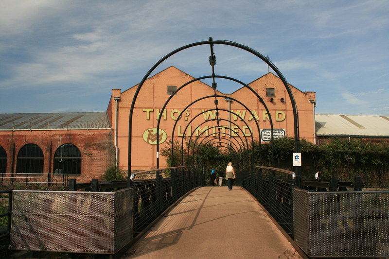
English: The Bailey Bridge Erected here in 2006 to carry the Five Weirs Walk over the River Don between Effingham Road and Thomas W. Ward's Albion Works. The bridge dates from WWII and is thought to have been used in the D-Day landings Five Weirs Walk The Five Weirs Walk is a 7.5km footpath and cycleway which follows the River Don from Lady's Bridge in Sheffield city centre to Meadowhall Retail & Leisure Centre on the city's eastern boundary. This stretch of river incorporates five weirs which were built as part of Sheffield's industrial evolution, and which give the walk its name. |
| Date | |
| Source | From geograph.org.uk |
| Author | Graham Hogg |
| Permission (Reusing this file) |
Creative Commons Attribution Share-alike license 2.0 |
| Attribution (required by the license) | Graham Hogg / The Bailey Bridge / |
| Camera location | | View this and other nearby images on: OpenStreetMap |
|---|
.jpg¶ms=053.388579_N_-001.453410_E_globe:Earth_type:camera_heading:337.00_source:geograph&language=en)
| Object location | | View this and other nearby images on: OpenStreetMap |
|---|
.jpg¶ms=053.388800_N_-001.453300_E_globe:Earth_class:object_type:object_source:geograph-osgb36(SK36458813)_region:GB-GBN_heading:337.00&language=en)
Licensing

|
This image was taken from the Geograph project collection. See this photograph's page on the Geograph website for the photographer's contact details. The copyright on this image is owned by Graham Hogg and is licensed for reuse under the Creative Commons Attribution-ShareAlike 2.0 license.
|
This file is licensed under the Creative Commons Attribution-Share Alike 2.0 Generic license.
Attribution: Graham Hogg
- You are free:
- to share – to copy, distribute and transmit the work
- to remix – to adapt the work
- Under the following conditions:
- attribution – You must give appropriate credit, provide a link to the license, and indicate if changes were made. You may do so in any reasonable manner, but not in any way that suggests the licensor endorses you or your use.
- share alike – If you remix, transform, or build upon the material, you must distribute your contributions under the same or compatible license as the original.
File history
Click on a date/time to view the file as it appeared at that time.
| Date/Time | Thumbnail | Dimensions | User | Comment | |
|---|---|---|---|---|---|
| current | 08:03, 28 July 2016 | | 800 × 533 (111 KB) | Eddaido | Transferred from geograph.co.uk using [https://tools.wmflabs.org/geograph2commons/ geograph2commons] |
File usage
The following pages on the English Wikipedia use this file (pages on other projects are not listed):
.jpg)