No higher resolution available.
Tegryn_village_centre_-_geograph.org.uk_-_516122.jpg (640 × 480 pixels, file size: 59 KB, MIME type: image/jpeg)
| This is a file from the Wikimedia Commons. Information from its description page there is shown below. Commons is a freely licensed media file repository. You can help. |
Summary
| Description |
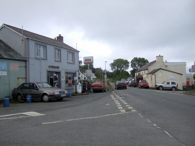
English: Tegryn village centre Tegryn is a small, mainly agricultural community, high in the Preseli hills, with a pub, post office, two garages, chapel and an area primary school in the village. Within living memory that the village contained, in addition, 4 shops, 2 tailors, a seamstress, a cobbler, an egg trader, a bus proprietor, and in close proximity to the village a woollen mill and a blacksmith. Nevertheless, even with reduced amenities it remains a thriving centre of local rural life.
The garage on the left in the image looks as if it hasn't changed much in recent decades; the pub is straight ahead. The road leads north in the direction of Cardigan. The community has an interesting website with lots of local information: http://www.northpembrokeshire.co.uk/index.php |
| Date | |
| Source | From geograph.org.uk |
| Author | ceridwen |
| Attribution (required by the license) | ceridwen / Tegryn village centre / |
| Camera location | | View this and other nearby images on: OpenStreetMap |
|---|
_heading:0.00&language=en)
| Object location | | View this and other nearby images on: OpenStreetMap |
|---|
_heading:0.00&language=en)
Licensing

|
This image was taken from the Geograph project collection. See this photograph's page on the Geograph website for the photographer's contact details. The copyright on this image is owned by ceridwen and is licensed for reuse under the Creative Commons Attribution-ShareAlike 2.0 license.
|
This file is licensed under the Creative Commons Attribution-Share Alike 2.0 Generic license.
Attribution: ceridwen
- You are free:
- to share – to copy, distribute and transmit the work
- to remix – to adapt the work
- Under the following conditions:
- attribution – You must give appropriate credit, provide a link to the license, and indicate if changes were made. You may do so in any reasonable manner, but not in any way that suggests the licensor endorses you or your use.
- share alike – If you remix, transform, or build upon the material, you must distribute your contributions under the same or compatible license as the original.
- Remove redundant categories and try to put this image in the most specific category/categories
- Remove this template
- The location categories are based on information from this geonames tool and this OpenStreetMap tool combined with a database. You can also have a look at this tool from mysociety.
- The topic category from Geograph was Village (find similar images at Geograph)
File history
Click on a date/time to view the file as it appeared at that time.
| Date/Time | Thumbnail | Dimensions | User | Comment | |
|---|---|---|---|---|---|
| current | 14:02, 5 February 2011 | | 640 × 480 (59 KB) | GeographBot | == {{int:filedesc}} == {{Information |description={{en|1=Tegryn village centre Tegryn is a small, mainly agricultural community, high in the Preseli hills, with a pub, post office, two garages, chapel and an area primary school in the village. Within livi |
File usage
The following pages on the English Wikipedia use this file (pages on other projects are not listed):
Global file usage
The following other wikis use this file: