
Size of this preview: 800 × 113 pixels. Other resolutions: 320 × 45 pixels | 640 × 90 pixels | 1,024 × 144 pixels | 1,280 × 180 pixels | 8,955 × 1,260 pixels.
Original file (8,955 × 1,260 pixels, file size: 1.16 MB, MIME type: image/jpeg)
| This is a file from the Wikimedia Commons. Information from its description page there is shown below. Commons is a freely licensed media file repository. You can help. |
Summary
| Description |
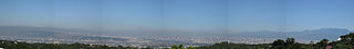
English: Taichung panoramic photography from Bagua Plateau in Changhua County,also called the Taichung Skyline,and it lies in the Taichung Basin. 中文(臺灣):台中全景圖可稱作台中天際線,位於台中盆地,在彰化縣八卦台地拍攝。 中文(简体):台中全景图可称作台中天际线,位于台中盆地,在彰化县八卦台地拍摄。 |
| Date | |
| Source | Own work |
| Author | Yiken |
| Annotations | This image is annotated: View the annotations at Commons |
Licensing
I, the copyright holder of this work, hereby publish it under the following licenses:
This file is licensed under the Creative Commons Attribution-Share Alike 3.0 Unported, 2.5 Generic, 2.0 Generic and 1.0 Generic license.
- You are free:
- to share – to copy, distribute and transmit the work
- to remix – to adapt the work
- Under the following conditions:
- attribution – You must give appropriate credit, provide a link to the license, and indicate if changes were made. You may do so in any reasonable manner, but not in any way that suggests the licensor endorses you or your use.
- share alike – If you remix, transform, or build upon the material, you must distribute your contributions under the same or compatible license as the original.

|
Permission is granted to copy, distribute and/or modify this document under the terms of the GNU Free Documentation License, Version 1.2 or any later version published by the Free Software Foundation; with no Invariant Sections, no Front-Cover Texts, and no Back-Cover Texts. A copy of the license is included in the section entitled GNU Free Documentation License. |
You may select the license of your choice.
File history
Click on a date/time to view the file as it appeared at that time.
| Date/Time | Thumbnail | Dimensions | User | Comment | |
|---|---|---|---|---|---|
| current | 09:04, 9 February 2010 | 8,955 × 1,260 (1.16 MB) | Yiken | {{Information |Description={{zh-hant|1=台中全景圖可稱作台中天際線,位於台中盆地,在彰化縣八卦台地拍攝。}} {{zh-hans|1=台中全景图可称作台中天际线,位于台中盆地,在彰化县八卦台地拍摄。}} {{en|1 |
File usage
The following pages on the English Wikipedia use this file (pages on other projects are not listed):
Global file usage
The following other wikis use this file: