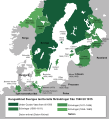
Size of this PNG preview of this SVG file: 547 × 600 pixels. Other resolutions: 219 × 240 pixels | 438 × 480 pixels | 701 × 768 pixels | 934 × 1,024 pixels | 1,868 × 2,048 pixels.
Original file (SVG file, nominally 800 × 877 pixels, file size: 508 KB)
File history
Click on a date/time to view the file as it appeared at that time.
| Date/Time | Thumbnail | Dimensions | User | Comment | |
|---|---|---|---|---|---|
| current | 06:58, 6 February 2021 |  | 800 × 877 (508 KB) | Chhrls | Uppdaterade gränserna I Sverige, fixade inkorrekta datum för besittningar som Svenska Pommern och mindre problem som att Blekinge inte fanns på kartan. |
| 13:15, 23 January 2021 |  | 800 × 877 (499 KB) | Chhrls | Fixade små detaljer gällande territorier erövrade från 1560 fram till 1611 | |
| 13:10, 23 January 2021 |  | 800 × 877 (499 KB) | Chhrls | Uppdaterade felstavningar och färger. Ändrade också lite mindre saker som "ända till" → "fram till" etc. | |
| 16:14, 13 January 2021 |  | 800 × 877 (501 KB) | Chhrls | Fixade datum för Halland och Gotland, la till/fixade städer som Pillau, Elbing, Memel, Riga, Kammin, Nöteborg och Viborg. Fixade namn för Karelen, Livonien, och Ingermanland, fixade statusen av Trondelag och Bornholm från ockuperade till erövrade. | |
| 20:58, 8 January 2021 |  | 800 × 877 (322 KB) | Chhrls | Uploaded a work by Charles (Chhrls) Memnon335bc from Gjort med: File:Swedish_Empire_(1560-1815)_blank.svg with UploadWizard |
File usage
The following pages on the English Wikipedia use this file (pages on other projects are not listed):
Global file usage
The following other wikis use this file:
- Usage on sv.wikipedia.org