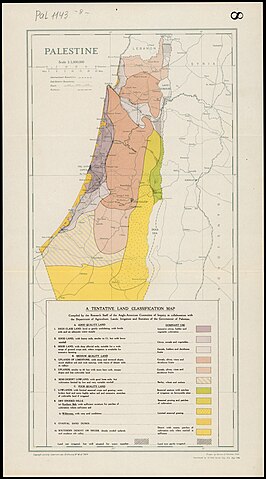
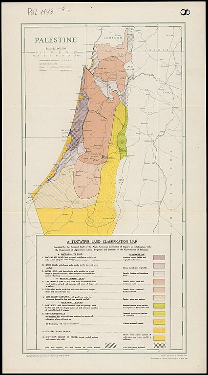
File:Survey of Palestine, Maps of Palestine 08-Land-Classification (FL147392109 2367029).jpg

Size of this preview: 332 × 598 pixels. Other resolutions: 133 × 240 pixels | 266 × 480 pixels | 426 × 768 pixels | 568 × 1,024 pixels | 1,136 × 2,048 pixels | 6,383 × 11,501 pixels.
Original file (6,383 × 11,501 pixels, file size: 73.78 MB, MIME type: image/jpeg)
| This is a file from the Wikimedia Commons. Information from its description page there is shown below. Commons is a freely licensed media file repository. You can help. |
Summary
| Survey of Palestine: Maps of Palestine
( |
||||||||||||||||||||||||
|---|---|---|---|---|---|---|---|---|---|---|---|---|---|---|---|---|---|---|---|---|---|---|---|---|
| Artist |
|
|||||||||||||||||||||||
| Title |
Maps of Palestine |
|||||||||||||||||||||||
| Description |
Maps of Palestine. Prepared for the information of The United Nations Special Committee of Enquiry. |
|||||||||||||||||||||||
| Language | English | |||||||||||||||||||||||
| Publication date | June 1947 | |||||||||||||||||||||||
| Collection |
|
|||||||||||||||||||||||
| Current location |
|
|||||||||||||||||||||||
| Notes | 9 maps (1. Near and Middle East; 2. Relief; 3. Rainfall; 4. Climatic Elements; 5. Population, December 1944; 6. Administrative Divisions; 7. Land Settlement 1947; 8. Land Classification; 9. Land in Jewish Possession and Zones...) | |||||||||||||||||||||||
| scale | 1:4,000,000 cm | |||||||||||||||||||||||
| IE PID | IE147392094 | |||||||||||||||||||||||
| Rosetta filename | FL147392109 | |||||||||||||||||||||||
| NNL item ID (P3959) | 990023670290205171 | |||||||||||||||||||||||
| search Merhav catalog | English, Survey of Palestine | |||||||||||||||||||||||
| Source/Photographer |
|
|||||||||||||||||||||||
| Other versions | ||||||||||||||||||||||||
| Jpg / Tif version |
|
|||||||||||||||||||||||

.jpg)

.jpg)
.jpg&action=edit&redlink=1)
.jpg)
Licensing
This work created by the United Kingdom Government is in the public domain.
This is because it is one of the following:
HMSO has declared that the expiry of Crown Copyrights applies worldwide (ref: HMSO Email Reply)
|
 |
This work was created or ordered by the State of Israel, and is in the public domain because it satisfies one of the conditions stipulated in Israel's copyright statute from 2007 (translation) regarding the State's copyrights:
|

|
[[Category:]]
File history
Click on a date/time to view the file as it appeared at that time.
| Date/Time | Thumbnail | Dimensions | User | Comment | |
|---|---|---|---|---|---|
| current | 16:12, 12 August 2023 | | 6,383 × 11,501 (73.78 MB) | Geagea | pattypan 22.03 |
File usage
The following pages on the English Wikipedia use this file (pages on other projects are not listed):
Global file usage
The following other wikis use this file:
- Usage on ar.wikipedia.org
- Usage on es.wikipedia.org
.jpg)