
Size of this preview: 562 × 599 pixels. Other resolutions: 225 × 240 pixels | 450 × 480 pixels | 894 × 953 pixels.
Original file (894 × 953 pixels, file size: 517 KB, MIME type: image/jpeg)
Summary edit
| Description |
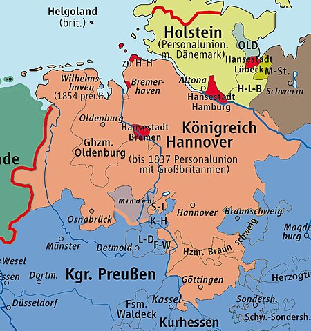
This map depicts the location of the Steuerverein or Tax Union in the 1840s in north west Germany. The Steuerverein was a customs union between the Kingdom of Hanover and some neighbouring states, as described in the Wikipedia article. |
|---|---|
| Source |
Wikicommons file: KrkHannover.png |
| Date |
1 February 2007 |
| Author |
kgberger |
| Permission (Reusing this file) |
Wikicommons File:KrkHannover.png |
| Other versions |  |
- Other information
The base file has been reworked by myself to accompany text in the Wikipedia article - Steuerverein. The source of the information is contained in that article. This involves re-colouring and some addition of borders
Licensing edit
 | Permission is granted to copy, distribute and/or modify this document under the terms of the GNU Free Documentation License, Version 1.2 or any later version published by the Free Software Foundation; with no Invariant Sections, no Front-Cover Texts, and no Back-Cover Texts. |
File history
Click on a date/time to view the file as it appeared at that time.
| Date/Time | Thumbnail | Dimensions | User | Comment | |
|---|---|---|---|---|---|
| current | 11:43, 6 January 2018 | | 894 × 953 (517 KB) | Tom1955 (talk | contribs) | Uploading a file from a free published source using File Upload Wizard |
You cannot overwrite this file.
File usage
The following pages on the English Wikipedia use this file (pages on other projects are not listed):