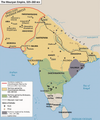
File:Standard Mauryan Empire.png

Original file (3,054 × 3,666 pixels, file size: 1.21 MB, MIME type: image/png)

Summary

Description
English: This is the standard "textbook" map of the Maurya Empire which is used globally in studies. It is accepted by globally by nearly all the Historians.

Some maps references:

  • ASI (Archeological Survey Of India) referenced rough map of Mauryan Empire : [1]
  • British Historian Geoffrey Parker created map on Mauryan Empire : [2]
  • British historian Patrick K. O'Brien created Mauryan Empire Map : [3]
  • American historian Gerald Danzer created Mauryan Empire Map : [4]
  • British Historian Charles Allen created Mauryan Empire Map : [5]
  • Historian Robert W. Strayer and Eric Nelson created Mauryan Empire Map : [6]
  • Irish Historian and Indologist Vincent Arthur Smith created Mauryan Empire Map : [7]
  • Anthropologist and Bioarcheologist Professor Ian Barnes created Mauryan Empire Map : [8]
  • By World History Encyclopaedia : [9]
  • Historical Geographer Charles Joppen created Mauryan Empire Map : [10]

Greek Historian on Empire extent(regarding Chandragupta) :

  • Greek historians mentioned the result of Seleucid–Mauryan war where Seleucid Empire's eastern satrapies( Gedrosia,Arachosia, Aria, and Paropamisadae) ceded to Mauryan Empire :
    • " Seleucus crossed the Indus and waged war with Sandrocottus [Maurya], king of he Indians, who dwelt on the banks of that stream, until they came to an understanding with each other and contracted a marriage relationship. Some of these exploits were performed before the death of Antigonus and some afterward."

— Appian, History of Rome, The Syrian Wars 55[11]

    • "The geographical position of the tribes is as follows: along the Indus are the Paropamisadae, above whom lies the Paropamisus mountain: then, towards the south, the Arachoti: then next, towards the south, the Gedroseni, with the other tribes that occupy the seaboard; and the Indus lies, latitudinally, alongside all these places; and of these places, in part, some that lie along the Indus are held by Indians, although they formerly belonged to the Persians. Alexander [III 'the Great' of Macedon] took these away from the Arians and established settlements of his own, but Seleucus Nicator gave them to Sandrocottus [Chandragupta], upon terms of intermarriage and of receiving in exchange five hundred elephants. "

— Strabo 15.2.9[12]

  • Greecian historian Pliny also quoted a passage from Megasthanes work about Chandragupta Empire boundaries:
    • " Most geographers, in fact, do not look upon India as bounded by the river Indus, but add to it the four satrapies of the Gedrose, the Arachotë, the Aria, and the Paropamisadë, the River Cophes thus forming the extreme boundary of India. According to other writers, however, all these territories, are reckoned as belonging to the country of the Aria. "

— Pliny, Natural History VI, 23[13]

  • Megasthenes defined the region that Chandragupta won from Seleucus as likely western side Gedrosia which shares boundaries with the Euphrates River, and eastern side Arachosia shares boundaries with the Indus. The northern frontier boundary formed by Hindukush mountain range:
    • " India, which is in shape quadrilateral, has its eastern as well as its 'western side bounded by the great sea, but on the northern side it is divided by Mount Hemôdos from that part of Skythia which is inhabited by those Skythians who are called the Sakai, while the fourth or western side is bounded by the river called the Indus. "

- Book I Fragment I , Indica, Megasthanes[14]

    • " Sandrokottos (Chandragupta) the king of the Indians, India forms the largest of the four parts into which Southern Asia is divided, while the smallest part is that region which is included between the Euphrates and our own sea. The two remaining parts, which are separated from the others by the Euphrates and the Indus, and lie between these rivers... India is bounded on its eastern side, right onwards to the south, by the great ocean; that its northern frontier is formed by the Kaukasos range(Hindukush Range) as far as the junction of that range with Tauros; and that the boundary."
- Book I Fragment II , Indica, Megasthanes[15]
Date
Source Own work
Author Buddhamitra sangha

Licensing

I, the copyright holder of this work, hereby publish it under the following license:
Creative Commons CC-Zero This file is made available under the Creative Commons CC0 1.0 Universal Public Domain Dedication.
The person who associated a work with this deed has dedicated the work to the public domain by waiving all of their rights to the work worldwide under copyright law, including all related and neighboring rights, to the extent allowed by law. You can copy, modify, distribute and perform the work, even for commercial purposes, all without asking permission.

Captions

Standard Mauryan Empire

Items portrayed in this file

depicts

8 December 2023

image/png

File history

Click on a date/time to view the file as it appeared at that time.

Date/TimeThumbnailDimensionsUserComment
current05:35, 9 February 2024Thumbnail for version as of 05:35, 9 February 20243,054 × 3,666 (1.21 MB)Buddhamitra sanghaMore clarification
22:37, 7 February 2024Thumbnail for version as of 22:37, 7 February 20243,054 × 3,666 (1.21 MB)Buddhamitra sanghaQuality
22:10, 7 February 2024Thumbnail for version as of 22:10, 7 February 20243,054 × 3,666 (695 KB)Buddhamitra sanghaCeded area correction
04:50, 8 December 2023Thumbnail for version as of 04:50, 8 December 20233,054 × 3,666 (1.43 MB)Buddhamitra sanghaUploaded own work with UploadWizard

The following 2 pages use this file:

Global file usage

Metadata