
Size of this preview: 800 × 466 pixels. Other resolutions: 320 × 186 pixels | 640 × 373 pixels | 1,024 × 597 pixels | 1,280 × 746 pixels | 3,301 × 1,923 pixels.
Original file (3,301 × 1,923 pixels, file size: 4.1 MB, MIME type: image/jpeg)
| This is a file from the Wikimedia Commons. Information from its description page there is shown below. Commons is a freely licensed media file repository. You can help. |
Summary
| Camera location | | View this and other nearby images on: OpenStreetMap |
|---|
| Description |
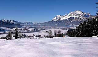
Deutsch: St. Johann in Tirol Kaisergebirge, von links nach rechts: Kitzbüheler Alpen, großer und kleiner Pölven, ganz hinten wahrscheinlich Pendling, Kaisergebirge (Treffauer, vermutlich das Sonneck, Ellmauer Halt, vermutlich Regalmwand, Ackerlspitze, Maukspitze, Lärcheck, vorgelagert der Niederkaiser) |
| Date | |
| Source | Own work |
| Author | HellasX |
Licensing
| Copyleft: This work of art is free; you can redistribute it and/or modify it according to terms of the Free Art License. You will find a specimen of this license on the Copyleft Attitude site as well as on other sites. |
File history
Click on a date/time to view the file as it appeared at that time.
| Date/Time | Thumbnail | Dimensions | User | Comment | |
|---|---|---|---|---|---|
| current | 15:26, 19 December 2007 | | 3,301 × 1,923 (4.1 MB) | HellasX | |
| 14:58, 19 December 2007 |  | 3,292 × 2,069 (4.24 MB) | HellasX | {{location dec|47.515920269602|12.468690898217}} {{Information |Description= St. Johann in Tirol Kaisergebirge |Source= HellasX |Date= 19. Dezember 2007 |Author= HellasX |Permission= |other_versions= }} == Licensing == { |
File usage
The following pages on the English Wikipedia use this file (pages on other projects are not listed):
Global file usage
The following other wikis use this file:
- Usage on de.wikipedia.org
- Usage on et.wikipedia.org