
Size of this preview: 800 × 423 pixels. Other resolutions: 320 × 169 pixels | 640 × 339 pixels | 1,024 × 542 pixels | 1,280 × 677 pixels | 3,266 × 1,728 pixels.
Original file (3,266 × 1,728 pixels, file size: 429 KB, MIME type: image/jpeg)
| This is a file from the Wikimedia Commons. Information from its description page there is shown below. Commons is a freely licensed media file repository. You can help. |
Summary
| Description |
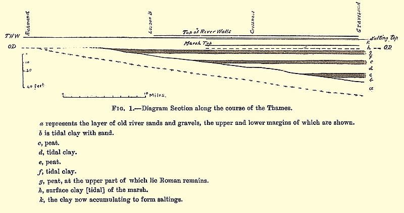
English: A section of the River Thames, Richmond to Gravesend (vertical scale exaggerated), showing successive layers of clay deposition and peat growth. One layer was datable by Roman pottery. From these observations Spurrell inferred that the land has been sinking relative to the sea, with occasional remissions. The tops of the river walls, by being topped up to prevent tidal overflow, have been keeping pace.
From Spurrell, F.C.J. (1889). "On the Estuary of the Thames and its Alluvium". Proceedings of the Geologists' Association. 11 (4). |
| Date | |
| Source | Spurrell, F.C.J. (1889). "On the Estuary of the Thames and its Alluvium". Proceedings of the Geologists' Association. 11 (4) |
| Author | F.C.J Spurrell |
Licensing
|
This work is in the public domain in its country of origin and other countries and areas where the copyright term is the author's life plus 70 years or fewer. This work is in the public domain in the United States because it was published (or registered with the U.S. Copyright Office) before January 1, 1929. | |
| This file has been identified as being free of known restrictions under copyright law, including all related and neighboring rights. | |
File history
Click on a date/time to view the file as it appeared at that time.
| Date/Time | Thumbnail | Dimensions | User | Comment | |
|---|---|---|---|---|---|
| current | 21:24, 18 December 2020 | | 3,266 × 1,728 (429 KB) | Ttocserp | Uploaded a work by F.C.J Spurrell from Spurrell, F.C.J. (1889). "On the Estuary of the Thames and its Alluvium". Proceedings of the Geologists' Association. 11 (4) with UploadWizard |
File usage
The following pages on the English Wikipedia use this file (pages on other projects are not listed):