
Size of this PNG preview of this SVG file: 605 × 446 pixels. Other resolutions: 320 × 236 pixels | 640 × 472 pixels | 1,024 × 755 pixels | 1,280 × 944 pixels | 2,560 × 1,887 pixels.
Original file (SVG file, nominally 605 × 446 pixels, file size: 1.37 MB)
| This is a file from the Wikimedia Commons. Information from its description page there is shown below. Commons is a freely licensed media file repository. You can help. |
Summary
| Description |
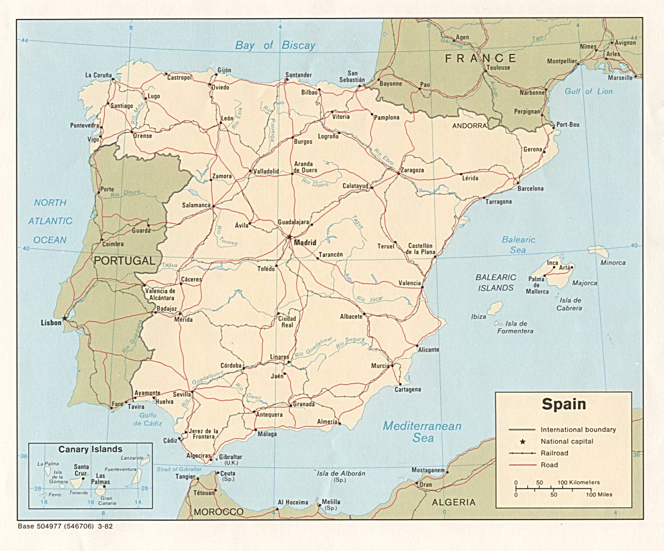
English: Spain regions map (Inkscape SVG). |
| Date | |
| Source | Own work based on Comunitats_autònomes_d'Espanya.svg by Joan M. Borràs, and the Perry-Castañeda Library Map Collection - University of Texas Libraries |
| Author | Peter Fitzgerald |
| Other versions |
SVG derivatives: PNG files: |
| Other information |
.png)
.png)
.png)
Licensing
This file is licensed under the Creative Commons Attribution-Share Alike 2.5 Generic license.
- You are free:
- to share – to copy, distribute and transmit the work
- to remix – to adapt the work
- Under the following conditions:
- attribution – You must give appropriate credit, provide a link to the license, and indicate if changes were made. You may do so in any reasonable manner, but not in any way that suggests the licensor endorses you or your use.
- share alike – If you remix, transform, or build upon the material, you must distribute your contributions under the same or compatible license as the original.
Original upload log
| This file was imported from Wikivoyage WTS. |
The original description page was here. All following user names refer to wts.wikivoyage-old.
- 2009-02-01 20:52 (WT-shared) Peterfitzgerald archive copy at the Wayback Machine 644×458 (1405294 bytes) {{Imagecredit|credit=Peter Fitzgerald, [http://ca.wikipedia.org/wiki/Usuari:Ebrenc Joan M. Borràs]|captureDate=16 January 2009|location=Spa (Import from wikitravel.org/shared)
- 2009-02-01 20:59 (WT-shared) Peterfitzgerald archive copy at the Wayback Machine 644×458 (1406248 bytes) ru map fix (Import from wikitravel.org/shared)
- 2012-09-29 00:03 Globe-trotter[dead link] 605×446 (1434480 bytes) changed regions
File history
Click on a date/time to view the file as it appeared at that time.
| Date/Time | Thumbnail | Dimensions | User | Comment | |
|---|---|---|---|---|---|
| current | 17:25, 24 January 2013 | | 605 × 446 (1.37 MB) | Globe-trotter | added text, changes to Dutch translation |
| 18:50, 23 January 2013 |  | 605 × 446 (1.37 MB) | Globe-trotter | added Ceuta and Melilla, Murcia to Eastern Spain | |
| 13:34, 22 December 2012 |  | 605 × 446 (1.37 MB) | OgreBot | (BOT): Reverting to most recent version before archival | |
| 13:34, 22 December 2012 |  | 644 × 458 (1.34 MB) | OgreBot | (BOT): Uploading old version of file from wts.wikivoyage; originally uploaded on 2009-02-01 20:59:39 by (WT-shared) Peterfitzgerald | |
| 13:34, 22 December 2012 |  | 644 × 458 (1.34 MB) | OgreBot | (BOT): Uploading old version of file from wts.wikivoyage; originally uploaded on 2009-02-01 20:52:13 by (WT-shared) Peterfitzgerald | |
| 02:53, 18 November 2012 |  | 605 × 446 (1.37 MB) | MGA73bot2 | {{BotMoveToCommons|wts.oldwikivoyage|year={{subst:CURRENTYEAR}}|month={{subst:CURRENTMONTHNAME}}|day={{subst:CURRENTDAY}}}} == {{int:filedesc}} == {{Information |description=Spain regions map. '''SVG derivatives:''' *[[:wts::Image:Iberia regions map.s... |
File usage
The following pages on the English Wikipedia use this file (pages on other projects are not listed):
Global file usage
The following other wikis use this file:
- Usage on gl.wikipedia.org