
Size of this preview: 800 × 534 pixels. Other resolutions: 320 × 214 pixels | 640 × 427 pixels | 1,024 × 683 pixels | 1,500 × 1,001 pixels.
Original file (1,500 × 1,001 pixels, file size: 814 KB, MIME type: image/jpeg)
| This is a file from the Wikimedia Commons. Information from its description page there is shown below. Commons is a freely licensed media file repository. You can help. |
| Description |
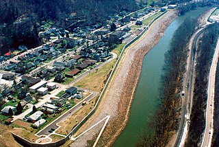
English: Aerial view of South Williamson, Kentucky, USA. The town is protected by a floodwall built along the Tug Fork River by the U.S. Army Corps of Engineers. The river here is the border between Kentucky and West Virginia. The view in this photograph is from the West Virginia side looking south-southwest over the river to South Williamson, Kentucky. |
|||
| Location | South Williamson, Kentucky, USA 37°40′20.97″N 82°17′4.92″W / 37.6724917°N 82.2847°W |
|||
| Date | ||||
| Source |
U.S. Army Corps of Engineers Digital Visual Library Image page Image description page Digital Visual Library home page |
|||
| Author | U.S. Army Corps of Engineers, photographer not specified or unknown | |||
| Permission (Reusing this file) |
|
File history
Click on a date/time to view the file as it appeared at that time.
| Date/Time | Thumbnail | Dimensions | User | Comment | |
|---|---|---|---|---|---|
| current | 01:21, 22 March 2007 | | 1,500 × 1,001 (814 KB) | DanMS | {{Information | Description = {{en|Aerial view of South Williamson, Kentucky, USA. The town is protected by a floodwall built along the Tug Fork River by the U.S. Army Corps of Engineers.}} | Source = U.S. Army Corps of Engineers Digital Visual |
File usage
The following pages on the English Wikipedia use this file (pages on other projects are not listed):
Global file usage
The following other wikis use this file:
- Usage on azb.wikipedia.org
- Usage on ceb.wikipedia.org
- Usage on ce.wikipedia.org
- Usage on es.wikipedia.org
- Usage on fa.wikipedia.org
- Usage on lld.wikipedia.org
- Usage on pl.wikipedia.org
- Usage on sr.wikipedia.org
- Usage on tt.wikipedia.org
- Usage on uk.wikipedia.org
- Usage on www.wikidata.org
- Usage on zh.wikipedia.org