
Size of this preview: 500 × 600 pixels. Other resolutions: 200 × 240 pixels | 400 × 480 pixels.
Original file (800 × 960 pixels, file size: 74 KB, MIME type: image/gif)
| This is a file from the Wikimedia Commons. Information from its description page there is shown below. Commons is a freely licensed media file repository. You can help. |
Summary
| Description |
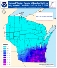
English: Map of snowfall amounts across Wisconsin during a winter storm event on February 5-6, 2008 which was associated with the system that spawned a tornado outbreak over the Mid-Mississippi, Ohio and Tennessee Valleys at the same time. |
| Source | Own work |
| Author |
Highest amounts are situated along the eastern shore lines of Lake Michigan where lake enhancement snows may have increased the amounts and across most of southern Wisconsin up to eastern Iowa. (Courtesy of NWS Milwaukee, Wisconsin)
Source: http://www.crh.noaa.gov/crnews/display_story.php?wfo=mkx&storyid=12790&source=0
Licensing
This image is in the public domain because it contains materials that originally came from the U.S. National Oceanic and Atmospheric Administration, taken or made as part of an employee's official duties.
|
Original upload log
Transferred from en.wikipedia to Commons using For the Common Good.
The original description page was here. All following user names refer to en.wikipedia.
| Date/Time | Dimensions | User | Comment |
|---|---|---|---|
| 19:16, 8 February 2008 | 800 × 960 (75,884 bytes) | w:en:JForget (talk | contribs) | (Map of snowfall amounts across Wisconsin during a winter storm event on February 5-6, 2008 which was associated with the system that spawned a tornado outbreak over the Mid-Mississippi, Ohio and Tennessee Valleys at the same time. Highest amounts are sit) |
File history
Click on a date/time to view the file as it appeared at that time.
| Date/Time | Thumbnail | Dimensions | User | Comment | |
|---|---|---|---|---|---|
| current | 19:20, 12 May 2013 | | 800 × 960 (74 KB) | Addihockey10 | Transferred from en.wikipedia: see original upload log above |
File usage
The following pages on the English Wikipedia use this file (pages on other projects are not listed):