No higher resolution available.
Site_of_Tindale_spelter_works_-_geograph.org.uk_-_1539906.jpg (640 × 480 pixels, file size: 76 KB, MIME type: image/jpeg)
| This is a file from the Wikimedia Commons. Information from its description page there is shown below. Commons is a freely licensed media file repository. You can help. |
Summary
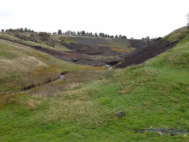
| Description |
English: Site of Tindale spelter works A large works existed here during the 19th century to extract zinc from spent lead ore brought down from Alston Moor. The works closed in 1895 when Lady Carlisle, the landlord, insisted on high standards for workers' houses, which proved uneconomic for the operators to provide. The works were reopened briefly twice in the 20th century. In the 1950s, the huge quanitity of waste material was used as hardcore in the construction of the Blue Streak rocket testing facility at Spadeadam. Small quantites of slag can still be seen on the slopes. |
| Date | |
| Source | From geograph.org.uk |
| Author | Oliver Dixon |
| Attribution (required by the license) | Oliver Dixon / Site of Tindale spelter works / |
| Camera location | | View this and other nearby images on: OpenStreetMap |
|---|
_heading:90.00&language=en)
| Object location | | View this and other nearby images on: OpenStreetMap |
|---|
_heading:90.00&language=en)
Licensing

|
This image was taken from the Geograph project collection. See this photograph's page on the Geograph website for the photographer's contact details. The copyright on this image is owned by Oliver Dixon and is licensed for reuse under the Creative Commons Attribution-ShareAlike 2.0 license.
|
This file is licensed under the Creative Commons Attribution-Share Alike 2.0 Generic license.
Attribution: Oliver Dixon
- You are free:
- to share – to copy, distribute and transmit the work
- to remix – to adapt the work
- Under the following conditions:
- attribution – You must give appropriate credit, provide a link to the license, and indicate if changes were made. You may do so in any reasonable manner, but not in any way that suggests the licensor endorses you or your use.
- share alike – If you remix, transform, or build upon the material, you must distribute your contributions under the same or compatible license as the original.
File history
Click on a date/time to view the file as it appeared at that time.
| Date/Time | Thumbnail | Dimensions | User | Comment | |
|---|---|---|---|---|---|
| current | 07:33, 3 March 2011 | | 640 × 480 (76 KB) | GeographBot | == {{int:filedesc}} == {{Information |description={{en|1=Site of Tindale spelter works A large works existed here during the 19th century to extract zinc from spent lead ore brought down from Alston Moor. The works closed in 1895 when Lady Carlisle, the l |
File usage
The following pages on the English Wikipedia use this file (pages on other projects are not listed):