.jpg)
.jpg&action=edit&redlink=1)

Original file (4,000 × 3,000 pixels, file size: 2.16 MB, MIME type: image/jpeg)
| This is a file from the Wikimedia Commons. Information from its description page there is shown below. Commons is a freely licensed media file repository. You can help. |
.jpg)
Summary
| Description |
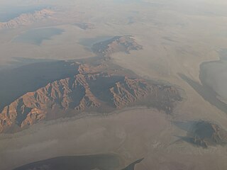
The Silver Island Range, (also called Silver Island Mountains), is a mountain range in Utah, in the northwest corner of Tooele County and the southwest corner of Box Elder County, about 15 miles (24 km) northeast of Wendover. The Silver Island Range lies at the west perimeter of the Great Salt Lake Desert; the southeast flank of the range is on the northwest border of the Bonneville Salt Flats. The Silver Island Range is a rough triangular area which extends 32 miles (51 km) into Utah from the Utah - Nevada border, with the Pilot Valley Playa to the west and the Great Salt Lake Desert to the east. The wilderness area includes 35,300 acres (14,300 ha) with sloping stream terraces, foothills, canyons, and steep mountains. Elevation starts at 5,200 feet (1,600 m) at the base of the range, to more than 7,000 feet (2,100 m) at the summits. The two tallest peaks in the range are Graham Peak, at 7,563 feet (2,305 m), and Cobb Peak, at 7,021 feet (2,140 m). With no perennial streams, vegetation on the rocky slopes is sparse, consisting of juniper, sagebrush, ricegrass and ephedra along with other desert shrubs and grasses. Bedrock in the range includes faulted and folded fossil bearing limestones. The slopes of the range have been terraced by shoreline erosion and deposition from Lake Bonneville. Historically, several caves in the Silver Island Range served as habitation for Native Americans. The range also played a role in the more recent mining history of the region, and stood as both a barrier and landmark to pioneers who crossed the inhospitable Salt Lake Desert. Donner Canyon in the northeast section of the range bears the name of the Donner-Reed party, who passed north of the area on the Hastings Cutoff. <a href="https://en.wikipedia.org/wiki/Silver_Island_Range" rel="noreferrer nofollow">en.wikipedia.org/wiki/Silver_Island_Range</a> <a href="https://en.wikipedia.org/wiki/Wikipedia:Text_of_Creative_Commons_Attribution-ShareAlike_3.0_Unported_License" rel="noreferrer nofollow">en.wikipedia.org/wiki/Wikipedia:Text_of_Creative_Commons_...</a> |
| Date | |
| Source | Silver Island Range, Utah |
| Author | Ken Lund from Reno, Nevada, USA |
| Camera location | | View this and other nearby images on: OpenStreetMap |
|---|
.jpg¶ms=040.893044_N_-113.888730_E_globe:Earth_type:camera_source:Flickr_&language=en)
Licensing
- You are free:
- to share – to copy, distribute and transmit the work
- to remix – to adapt the work
- Under the following conditions:
- attribution – You must give appropriate credit, provide a link to the license, and indicate if changes were made. You may do so in any reasonable manner, but not in any way that suggests the licensor endorses you or your use.
- share alike – If you remix, transform, or build upon the material, you must distribute your contributions under the same or compatible license as the original.
| This image was originally posted to Flickr by Ken Lund at https://flickr.com/photos/75683070@N00/21704962881. It was reviewed on 31 March 2022 by FlickreviewR 2 and was confirmed to be licensed under the terms of the cc-by-sa-2.0. |
File history
Click on a date/time to view the file as it appeared at that time.
| Date/Time | Thumbnail | Dimensions | User | Comment | |
|---|---|---|---|---|---|
| current | 23:46, 31 March 2022 | | 4,000 × 3,000 (2.16 MB) | Animalparty | Transferred from Flickr via #flickr2commons |
.jpg)