No higher resolution available.
Scolt_Head_Island,_marram_grass_zone_-_geograph.org.uk_-_1384108.jpg (640 × 480 pixels, file size: 192 KB, MIME type: image/jpeg)
| This is a file from the Wikimedia Commons. Information from its description page there is shown below. Commons is a freely licensed media file repository. You can help. |
Summary
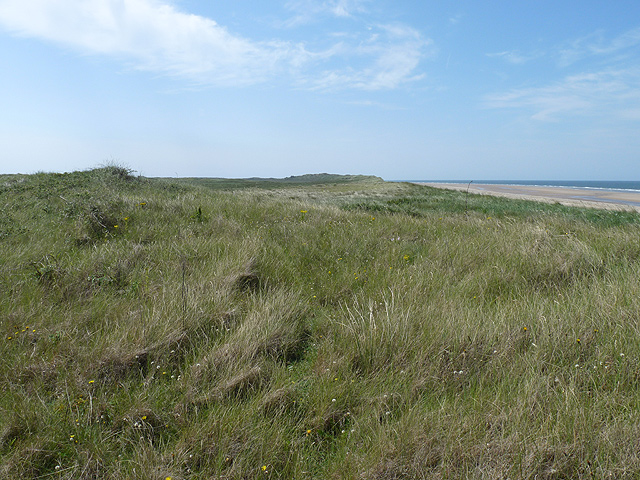
| Description |
English: Scolt Head Island: marram grass zone Although there are small dunes to the east and larger sand hills to the west, the central part of the north shore of Scolt Head Island looks like this: a flat, low landscape covered in marram grass, which helps to hold it together. This contrasts to the lunar landscape of sandhills and erosion on the east side of the Burn estuary, as here:909503 |
| Date | |
| Source | From geograph.org.uk |
| Author | Zorba the Geek |
| Attribution (required by the license) | Zorba the Geek / Scolt Head Island: marram grass zone / |
| Camera location | | View this and other nearby images on: OpenStreetMap |
|---|
_heading:270.00&language=en)
| Object location | | View this and other nearby images on: OpenStreetMap |
|---|
_heading:270.00&language=en)
Licensing

|
This image was taken from the Geograph project collection. See this photograph's page on the Geograph website for the photographer's contact details. The copyright on this image is owned by Zorba the Geek and is licensed for reuse under the Creative Commons Attribution-ShareAlike 2.0 license.
|
This file is licensed under the Creative Commons Attribution-Share Alike 2.0 Generic license.
Attribution: Zorba the Geek
- You are free:
- to share – to copy, distribute and transmit the work
- to remix – to adapt the work
- Under the following conditions:
- attribution – You must give appropriate credit, provide a link to the license, and indicate if changes were made. You may do so in any reasonable manner, but not in any way that suggests the licensor endorses you or your use.
- share alike – If you remix, transform, or build upon the material, you must distribute your contributions under the same or compatible license as the original.
File history
Click on a date/time to view the file as it appeared at that time.
| Date/Time | Thumbnail | Dimensions | User | Comment | |
|---|---|---|---|---|---|
| current | 19:32, 28 February 2011 | | 640 × 480 (192 KB) | GeographBot | == {{int:filedesc}} == {{Information |description={{en|1=Scolt Head Island: marram grass zone Although there are small dunes to the east and larger sand hills to the west, the central part of the north shore of Scolt Head Island looks like this: a flat, l |
File usage
The following pages on the English Wikipedia use this file (pages on other projects are not listed):