File:Schilderingen koorgewelf - Alkmaar - 20005828 - RCE.jpg

Original file(3,276 × 2,436 pixels, file size: 2.33 MB, MIME type: image/jpeg)

Summary

Object

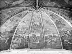
Jacob Cornelisz van Oostsanen: Painted ceiling vault with the Last Judgement  wikidata:Q107506071 reasonator:Q107506071
Artist
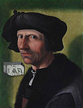
Jacob Cornelisz van Oostsanen  (circa 1472/1477–1533)  wikidata:Q1029143
 
Jacob Cornelisz van Oostsanen
Alternative names
Jacob Cornelisz. van Amsterdam, Jacob Cornelisz. van Oostzanen
Jakob Cornelisz. van Oostzanen, Jacob van Amsterdam
Jacob van Oostsanen, Jacob van Oostzanen
Description Dutch painter, drawer and printmaker
Date of birth/death circa 1472–1477 before 18 October 1533
date QS:P,+1533-10-18T00:00:00Z/7,P1326,+1533-10-18T00:00:00Z/11
Location of birth/death Oostzaan Amsterdam
Work period 1487 Edit this at Wikidata–1533 Edit this at Wikidata
Work location
Authority file
creator QS:P170,Q1029143
 Edit this at Wikidata
image of artwork listed in title parameter on this page
Title
Dutch:
Gewelfschildering met Het Laatste Oordeel Edit this at Wikidata

Painted ceiling vault with the Last Judgement
title QS:P1476,nl:"Gewelfschildering met Het Laatste Oordeel Edit this at Wikidata"
label QS:Lnl,"Gewelfschildering met Het Laatste Oordeel Edit this at Wikidata"
label QS:Len,"Painted ceiling vault with the Last Judgement"
Object type painting Edit this at Wikidata
Genre religious art Edit this at Wikidata
Description
Nederlands: Grote- of St.Laurenskerk: Schilderingen koorgewelf
This is an image of rijksmonument number 7258

Information from structured data:

Address
InfoField
Alkmaar
Netherlands
Date circa  Edit this at Wikidata
Medium oil on panel Edit this at Wikidata
Dimensions height: 275 cm (108.2 in) Edit this at Wikidata; width: 600 cm (19.6 ft) Edit this at Wikidata
dimensions QS:P2048,+275U174728
dimensions QS:P2049,+600U174728
institution QS:P195,Q190804
References

Photograph

Date
Source Rijksdienst voor het Cultureel Erfgoed
Author Unknown authorUnknown author
Object location52° 37′ 56.89″ N, 4° 44′ 40.31″ E Kartographer map based on OpenStreetMap.View this and other nearby images on: OpenStreetMapinfo

Licensing

w:en:Creative Commons
attribution share alike
This file is licensed under the Creative Commons Attribution-Share Alike 4.0 International license.
You are free:
  • to share – to copy, distribute and transmit the work
  • to remix – to adapt the work
Under the following conditions:
  • attribution – You must give appropriate credit, provide a link to the license, and indicate if changes were made. You may do so in any reasonable manner, but not in any way that suggests the licensor endorses you or your use.
  • share alike – If you remix, transform, or build upon the material, you must distribute your contributions under the same or compatible license as the original.

Captions

Add a one-line explanation of what this file represents

Items portrayed in this file

depicts

July 1942

52°37'56.89"N, 4°44'40.31"E

image/jpeg

File history

Click on a date/time to view the file as it appeared at that time.

Date/TimeThumbnailDimensionsUserComment
current19:13, 2 April 2022Thumbnail for version as of 19:13, 2 April 20223,276 × 2,436 (2.33 MB)Vysotskyhigher res. from same source
14:01, 25 December 2012Thumbnail for version as of 14:01, 25 December 20121,200 × 892 (264 KB)BotMultichill{{subst:RCE data ingestion layout|subst=subst: |@attributes_created=2009-05-18T23:39:00 |@attributes_modification=2012-10-25T09:24:22 |@attributes_priref=20005828 |@attributes_selected=False |Alternative_number_alternative_number=355 |Alternative_numbe...
The following pages on the English Wikipedia use this file (pages on other projects are not listed):

Global file usage

Metadata