
Size of this preview: 799 × 294 pixels. Other resolutions: 320 × 118 pixels | 640 × 236 pixels | 1,024 × 377 pixels | 2,100 × 773 pixels.
Original file (2,100 × 773 pixels, file size: 171 KB, MIME type: image/jpeg)
| This is a file from the Wikimedia Commons. Information from its description page there is shown below. Commons is a freely licensed media file repository. You can help. |
Summary
| Description |
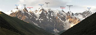
Čeština: Panorama hlavního kavkazského hřebene mezi horami Katyn-Tau a Šchara. Černě: názvy dle ruských průvodců z různých zdrojů (například Naumov (1985): Gory Svanetii), neuvedené v topografických mapách. English: Main Caucasus Ridge panorama between Katyn-Tau and Shkara peaks from georgian side. Black: Names from russian guides (different sources - for example Naumov (1985): Gory Svanetii). |
| Date | |
| Source | Own work |
| Author | Tadeáš Gregor |
| Other versions |
|
| Camera location | | View this and other nearby images on: OpenStreetMap |
|---|
Licensing
I, the copyright holder of this work, hereby publish it under the following license:
This file is licensed under the Creative Commons Attribution-Share Alike 3.0 Unported license.
- You are free:
- to share – to copy, distribute and transmit the work
- to remix – to adapt the work
- Under the following conditions:
- attribution – You must give appropriate credit, provide a link to the license, and indicate if changes were made. You may do so in any reasonable manner, but not in any way that suggests the licensor endorses you or your use.
- share alike – If you remix, transform, or build upon the material, you must distribute your contributions under the same or compatible license as the original.
File history
Click on a date/time to view the file as it appeared at that time.
| Date/Time | Thumbnail | Dimensions | User | Comment | |
|---|---|---|---|---|---|
| current | 10:19, 27 March 2016 | 2,100 × 773 (171 KB) | Grtek | added heights from peakbagger, corrected Lakuca | |
| 20:32, 28 May 2012 | 2,112 × 727 (721 KB) | Grtek |
File usage
The following pages on the English Wikipedia use this file (pages on other projects are not listed):
Global file usage
The following other wikis use this file:
- Usage on bg.wikipedia.org
- Usage on cs.wikipedia.org
- Usage on es.wikipedia.org
- Usage on fa.wikipedia.org
- Usage on fr.wikipedia.org
- Usage on sw.wikipedia.org
- Usage on uk.wikipedia.org