
Size of this preview: 800 × 533 pixels. Other resolutions: 320 × 213 pixels | 640 × 427 pixels | 1,024 × 683 pixels | 1,280 × 853 pixels | 2,560 × 1,707 pixels | 6,000 × 4,000 pixels.
Original file (6,000 × 4,000 pixels, file size: 23.1 MB, MIME type: image/jpeg)
| This is a file from the Wikimedia Commons. Information from its description page there is shown below. Commons is a freely licensed media file repository. You can help. |
Summary
| Description |
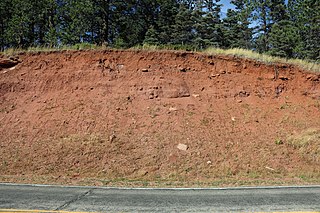
English: A roadcut showing the Sangre de Cristo Formation. This is along Colorado State Highway 12 in the southern part of Cuchara, Colorado. |
| Date | |
| Source | Own work |
| Author | Jeffrey Beall |
| Camera location | | View this and other nearby images on: OpenStreetMap |
|---|
Licensing
I, the copyright holder of this work, hereby publish it under the following license:
This file is licensed under the Creative Commons Attribution 4.0 International license.
- You are free:
- to share – to copy, distribute and transmit the work
- to remix – to adapt the work
- Under the following conditions:
- attribution – You must give appropriate credit, provide a link to the license, and indicate if changes were made. You may do so in any reasonable manner, but not in any way that suggests the licensor endorses you or your use.
File history
Click on a date/time to view the file as it appeared at that time.
| Date/Time | Thumbnail | Dimensions | User | Comment | |
|---|---|---|---|---|---|
| current | 12:03, 3 October 2019 | | 6,000 × 4,000 (23.1 MB) | Jeffrey Beall | {{Information |description ={{en|1=A roadcut showing the {{W|Sangre de Cristo Formation}}. This is along {{W|Colorado State Highway 12}} in the southern part of {{W|Cuchara, Colorado}}.}} |date =2019-10-01 |source ={{own}} |author =User:Jeffrey Beall }} {{Location|37|21|21.76|N|105|6|21.08|W}} Category:Road cuttings Category:Colorado State Highway 12 Category:Geologic formations Category:October 2019 in Colorado Category:Cuchara, Colorado |
File usage
The following pages on the English Wikipedia use this file (pages on other projects are not listed):