File:Salisbury Plain warning sign.jpg

Salisbury_Plain_warning_sign.jpg(272 × 277 pixels, file size: 96 KB, MIME type: image/jpeg)

Summary

Description
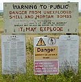
English: A warning sign at the military firing range near Market Lavington on Salisbury Plain, UK. ; Warning to public
Danger from unexploded shell and mortar bombs
Upon entering the training area you must stay on public rights of way.
On no account should any object be moved or touched.
It may explode
Français : Ce panneau situé en périphérie d'un site de tir militaire (d'exercice) dit "Market Lavington", dans la plaine de Salisbury au Royaume-Uni dit : "Avertissement au public ; Danger ; présence de munitions non-explosées, dont obus de mortier  ; Si vous pénétrez dans la zone d'entraînement, vous devez rester sur les emprises publiques. En aucun cas un objet quelconque doit déplacé ou touché. Il peut exploser"
Date
Source This file was derived from: Warning Notices on Salisbury Plain - geograph.org.uk - 83638.jpg
Author Rog Frost
Permission
(Reusing this file)
Creative Commons Attribution Share-alike license 2.0
Camera location51° 17′ 19.43″ N, 1° 57′ 24.95″ W Kartographer map based on OpenStreetMap.View this and other nearby images on: OpenStreetMapinfo

Licensing

w:en:Creative Commons
attribution share alike
This file is licensed under the Creative Commons Attribution-Share Alike 2.0 Generic license.
Attribution: Rog Frost
You are free:
  • to share – to copy, distribute and transmit the work
  • to remix – to adapt the work
Under the following conditions:
  • attribution – You must give appropriate credit, provide a link to the license, and indicate if changes were made. You may do so in any reasonable manner, but not in any way that suggests the licensor endorses you or your use.
  • share alike – If you remix, transform, or build upon the material, you must distribute your contributions under the same or compatible license as the original.

Captions

Add a one-line explanation of what this file represents

Items portrayed in this file

depicts

13 July 2002

51°17'19.43"N, 1°57'24.95"W

image/jpeg

File history

Click on a date/time to view the file as it appeared at that time.

Date/TimeThumbnailDimensionsUserComment
current12:13, 25 December 2022Thumbnail for version as of 12:13, 25 December 2022272 × 277 (96 KB)Sarangbotcolors maintained
19:54, 11 November 2008Thumbnail for version as of 19:54, 11 November 2008272 × 277 (60 KB)Ian Dunster~commonswiki Set levels.
17:37, 10 September 2006Thumbnail for version as of 17:37, 10 September 2006272 × 277 (56 KB)William Avery
17:25, 10 September 2006Thumbnail for version as of 17:25, 10 September 2006277 × 422 (86 KB)William Avery{{Information |Description=A warning sign at the militiary firing range near market lavington on Salisbury Plain, UK. |Source=Geograph http://www.geograph.org.uk/photo/83638 |Date=Friday, 30 June, 2006 |Author=Geograph user [http://www.geograph.org.uk/pr
The following pages on the English Wikipedia use this file (pages on other projects are not listed):

Global file usage

The following other wikis use this file:

Metadata