Size of this preview: 280 × 598 pixels. Other resolutions: 112 × 240 pixels | 331 × 707 pixels.
Original file (331 × 707 pixels, file size: 5 KB, MIME type: image/png)
| This is a file from the Wikimedia Commons. Information from its description page there is shown below. Commons is a freely licensed media file repository. You can help. |
Summary
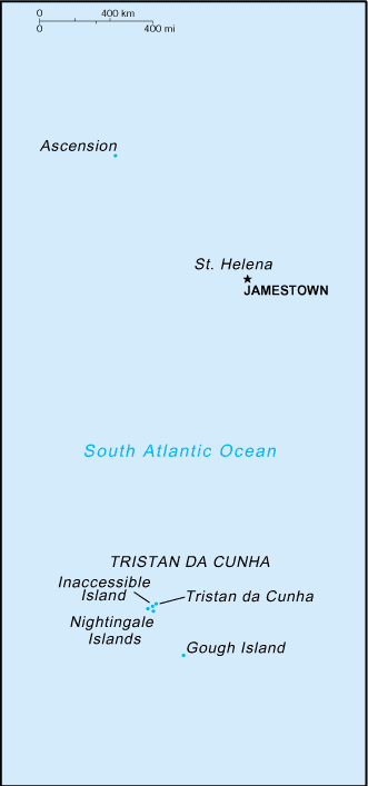
Español: Mapa de la dependencia de Santa Helena
Slovene version: Image:Saint Helena-CIA WFB Map-sl.png
This image is in the public domain because it contains materials that originally came from the United States Central Intelligence Agency's World Factbook.
|
 |
File history
Click on a date/time to view the file as it appeared at that time.
| Date/Time | Thumbnail | Dimensions | User | Comment | |
|---|---|---|---|---|---|
| current | 06:40, 14 November 2010 | | 331 × 707 (5 KB) | Hoshie | Reverted to version as of 09:17, 27 March 2005: a newer map is at Image:Saint Helena, Ascension, and Tristan da Cunha-CIA WFB Map.png |
| 08:27, 17 February 2006 |  | 329 × 713 (8 KB) | Hoshie | Updated map of St. Helena (and dependencies) from the CIA World Factbook, 10 Jan 06 rev. : http://www.cia.gov/cia/publications/factbook/maps/sh-map.gif | |
| 09:17, 27 March 2005 |  | 331 × 707 (5 KB) | Wolfman~commonswiki | {{CIA-map}} |
File usage
The following pages on the English Wikipedia use this file (pages on other projects are not listed):
Global file usage
The following other wikis use this file:
- Usage on ace.wikipedia.org
- Usage on ar.wikipedia.org
- Usage on ast.wikipedia.org
- Usage on ckb.wikipedia.org
- Usage on el.wikipedia.org
- Usage on en.wikisource.org
- Usage on eo.wikipedia.org
- Usage on es.wikipedia.org
- Usage on es.wikivoyage.org
- Usage on fr.wikipedia.org
- Usage on gl.wikipedia.org
- Usage on hu.wikipedia.org
- Usage on id.wikipedia.org
- Usage on jv.wikipedia.org
- Usage on no.wikipedia.org
- Usage on pl.wikipedia.org
- Usage on pl.wiktionary.org
- Usage on simple.wikipedia.org
- Usage on zh-min-nan.wikipedia.org