Size of this preview: 684 × 599 pixels. Other resolutions: 274 × 240 pixels | 548 × 480 pixels.
Original file (800 × 701 pixels, file size: 241 KB, MIME type: image/jpeg)
| This is a file from the Wikimedia Commons. Information from its description page there is shown below. Commons is a freely licensed media file repository. You can help. |
Summary
| Description |
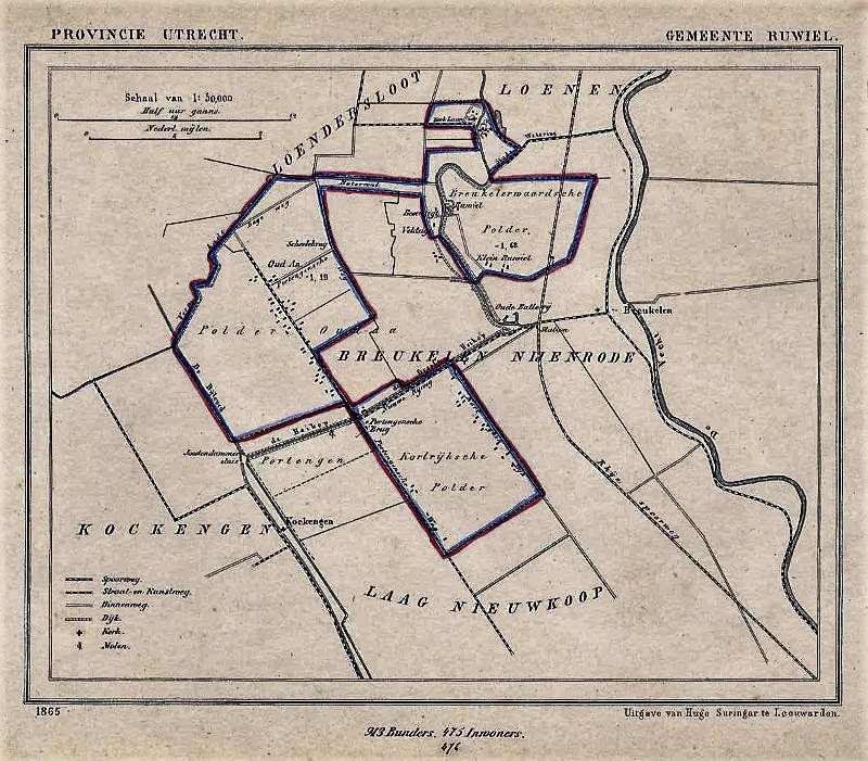
Nederlands: landkaart Ruwiel Dit is een kaart uit de gemeenteatlas van Utrecht, uitgegeven door Hugo Suringar te Leeuwarden. De gemeente was destijds 943 hectare groot en had 475 inwoners. Op de kaart staan de plaatsen Klein Ruwiel en Oud Aa. De originele kaart meet 18.5 bij 15 centimeter. De gemeentekaarten van Jacob Kuijper zijn uiterst gedetailleerd. Vaak zijn de huizen nog terug te vinden en de locaties kloppen ook vrij goed. Deze kaarten worden ook gebruikt om historische opgravingen te doen. |
| Date | |
| Source |
Transferred from nl.wikipedia |
| Author | Jacob Kuijper. Original uploader was Erikvank at nl.wikipedia |
| Permission (Reusing this file) |
PD-OUD. |
| Other versions |
_-_Breukelerwaardsche_Polder_met_kasteelrestant_Ruwiel_en_Klein_Ruwiel.jpg)
Licensing
|
This work is in the public domain in its country of origin and other countries and areas where the copyright term is the author's life plus 70 years or fewer. | |
| This file has been identified as being free of known restrictions under copyright law, including all related and neighboring rights. | |
Original upload log
The original description page was here. All following user names refer to nl.wikipedia.
- 2009-02-22 22:22 Erikvank 600×512× (68503 bytes) {{Information |Description=landkaart Ruwiel |Source=atlasenkaart.nl |Date=1865 |Author=Jacob Kuijper |Permission=auteursrecht verlopen |other_versions= }}
File history
Click on a date/time to view the file as it appeared at that time.
| Date/Time | Thumbnail | Dimensions | User | Comment | |
|---|---|---|---|---|---|
| current | 20:32, 30 October 2022 | | 800 × 701 (241 KB) | Hansmuller | enhanced + slightly more pixels |
| 21:22, 23 February 2009 |  | 600 × 512 (67 KB) | BotMultichill | {{BotMoveToCommons|nl.wikipedia|year={{subst:CURRENTYEAR}}|month={{subst:CURRENTMONTHNAME}}|day={{subst:CURRENTDAY}}}} {{Information |Description={{nl|landkaart Ruwiel<br/> Dit is een kaart uit de gemeenteatlas van Utrecht, uitgegeven door Hugo Suringar |
File usage
No pages on the English Wikipedia use this file (pages on other projects are not listed).