File:Route map of the Norfolk & Washington Steamboat Company - showing the Potomac River, Chesapeake Bay, and adjacent territory in Maryland and Virginia. LOC 89694335.jpg

Size of this preview: 800 × 471 pixels. Other resolutions: 320 × 189 pixels | 640 × 377 pixels | 1,024 × 603 pixels | 1,280 × 754 pixels | 2,560 × 1,508 pixels | 4,872 × 2,870 pixels.
Original file (4,872 × 2,870 pixels, file size: 2.16 MB, MIME type: image/jpeg)
| This is a file from the Wikimedia Commons. Information from its description page there is shown below. Commons is a freely licensed media file repository. You can help. |
Summary
| Description |
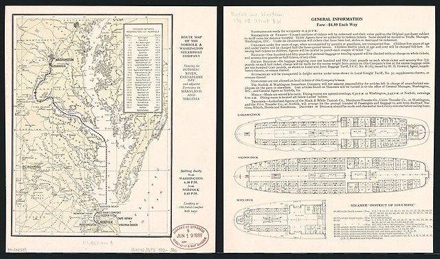
English: Includes notes and distance table. Text, 3 deck plans, and fare table on verso. Available also through the Library of Congress Web site as a raster image. |
||
| Title | Route map of the Norfolk & Washington Steamboat Company : showing the Potomac River, Chesapeake Bay, and adjacent territory in Maryland and Virginia. | ||
| Shelf ID | G3792.P6P5 192- .R6 | ||
| Date | |||
| Source | https://www.loc.gov/item/89694335/ | ||
| Author | Norfolk And Washington Steamboat Company | ||
| Permission (Reusing this file) |
|
||
| Other versions |
|
||
| Location | Chesapeake Bay · Potomac River Estuary · Virginia · United States · Chesapeake Bay Region · Maryland · Potomac River Region | ||
| Part of | American Memory · General Maps · Catalog · Geography And Map Division | ||
| Subject | Chesapeake Bay · Potomac River Estuary · Steamboat Lines · Virginia · United States · Maps · Potomac River Region · Chesapeake Bay Region · Maryland · Chesapeake Bay (Md. And Va.) · Norfolk And Washington Steamboat Company · Chesapeake Bay Region (Md. And Va.) |


Licensing
|
This is a faithful photographic reproduction of a two-dimensional, public domain work of art. The work of art itself is in the public domain for the following reason:
The official position taken by the Wikimedia Foundation is that "faithful reproductions of two-dimensional public domain works of art are public domain".
This photographic reproduction is therefore also considered to be in the public domain in the United States. In other jurisdictions, re-use of this content may be restricted; see Reuse of PD-Art photographs for details. | ||||
File history
Click on a date/time to view the file as it appeared at that time.
| Date/Time | Thumbnail | Dimensions | User | Comment | |
|---|---|---|---|---|---|
| current | 16:07, 7 June 2018 | | 4,872 × 2,870 (2.16 MB) | Fæ | LOC Maps https://www.loc.gov/item/89694335/ #7706 |
File usage
The following pages on the English Wikipedia use this file (pages on other projects are not listed):