
Size of this preview: 800 × 600 pixels. Other resolutions: 320 × 240 pixels | 640 × 480 pixels | 1,024 × 768 pixels | 1,280 × 960 pixels | 2,560 × 1,920 pixels | 7,200 × 5,400 pixels.
Original file (7,200 × 5,400 pixels, file size: 26.99 MB, MIME type: image/jpeg)
| This is a file from the Wikimedia Commons. Information from its description page there is shown below. Commons is a freely licensed media file repository. You can help. |
| Description |
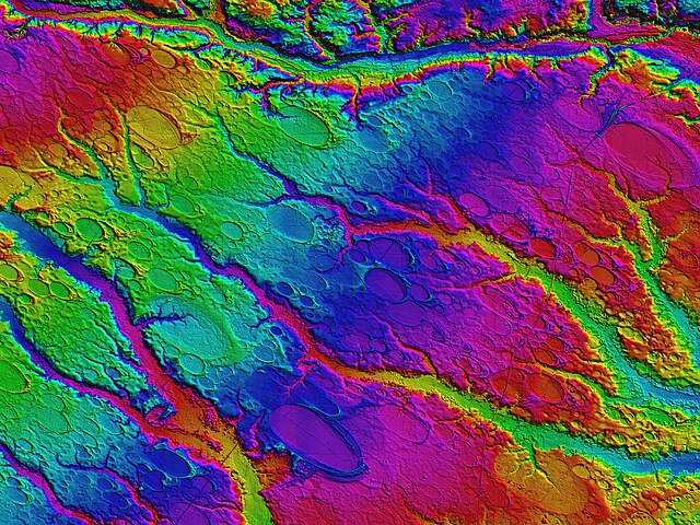
English: This Digital Elevation Map covers ~ 600 square km centered on Rex, NC (Robeson County). The colors shown are an indication of topographic elevation, from 16 m AMSL in the lower right, to 76 m in upper left. Vertical resolutions of centimeters allow for visualization of the form and extent of the bays’ otherwise imperceptible rims. Rockfish Creek flows along the northern edge. CSX’s Atlantic Coast Line rail bisects the area diagonally along a strikingly straight right-of-way; Interstate 95 winds N-S on the right. |
||
| Date | 10/7/2010 | ||
| Source | Generated by user Cintos using the commercially licensed Global Mapper GIS program using LiDAR-derived data from the USGS. | ||
| Author | Cintos (Michael Davias) | ||
| Permission (Reusing this file) |
|
| Camera location | | View this and other nearby images on: OpenStreetMap |
|---|
File history
Click on a date/time to view the file as it appeared at that time.
| Date/Time | Thumbnail | Dimensions | User | Comment | |
|---|---|---|---|---|---|
| current | 02:28, 29 January 2013 | | 7,200 × 5,400 (26.99 MB) | Slick-o-bot | Bot: convert to a non-interlaced jpeg (see bug #17645) |
| 19:53, 6 December 2010 |  | 7,200 × 5,400 (25.36 MB) | Cintos | {{Information |Description={{en|1=This Digital Elevation Map covers ~ 600 square km centered on Rex, NC (Robeson County). The colors shown are an indication of topographic elevation, from 16 m AMSL in the lower right, to 76 m in upper left. Vertical resol |
File usage
The following pages on the English Wikipedia use this file (pages on other projects are not listed):