
Size of this preview: 800 × 262 pixels. Other resolutions: 320 × 105 pixels | 640 × 209 pixels | 1,024 × 335 pixels | 3,074 × 1,005 pixels.
Original file (3,074 × 1,005 pixels, file size: 2.35 MB, MIME type: image/jpeg)
| This is a file from the Wikimedia Commons. Information from its description page there is shown below. Commons is a freely licensed media file repository. You can help. |
Summary
| Description |
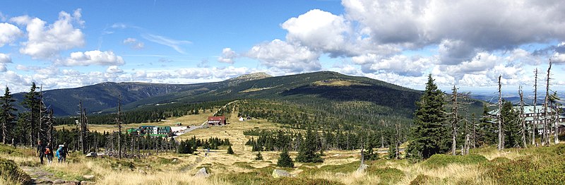
English: Panorama of Przełęcz Karkonoska
Français : Image panoramique montrant le col de Karkonoska, dans les Monts des Géants.
Polski: Przełęcz Karkonoska - panorama. Po prawej stronie Schronisko Odrodzenie. |
||
| Date | |||
| Source | Own work | ||
| Author |
|
||
| Permission (Reusing this file) |
|
||
| Other versions |
Derivative works of this file: |

| Object location | | View this and other nearby images on: OpenStreetMap |
|---|
This image was created with Hugin.
Assessment
This image was selected as picture of the day on Wikimedia Commons for 7 December 2010. It was captioned as follows: English: Przełęcz Karkonoska (literally the Karkonosze Pass) is a mountain pass (1198 m) in the central Karkonosze Mountains on the Polish-Czech border. Other languages:
English: Przełęcz Karkonoska (literally the Karkonosze Pass) is a mountain pass (1198 m) in the central Karkonosze Mountains on the Polish-Czech border. Español: Przełęcz Karkonoska, frontera checo-polaca. Français : Przełęcz Karkonoska est un col à 1 198 m dans le centre des Monts des Géants à la frontière entre la Pologne et la République tchèque. Íslenska: Víðmynd af fjallveginum Przełęcz Karkonoska á landamærum Póllands og Tékklands. Polski: Przełęcz Karkonoska Македонски: Карконошки Премин, Полска 日本語: ポーランド・チェコ国境のカルコノシェ峠 中文: 克尔科诺谢山口 |
|


|
This image has been assessed under the valued image criteria and is considered the most valued image on Commons within the scope: Przełęcz Karkonoska. You can see its nomination here. |
This image has been assessed using the Quality image guidelines and is considered a Quality image.
|
File history
Click on a date/time to view the file as it appeared at that time.
| Date/Time | Thumbnail | Dimensions | User | Comment | |
|---|---|---|---|---|---|
| current | 07:47, 28 July 2011 | 3,074 × 1,005 (2.35 MB) | VanWiel | exposure corrected | |
| 12:46, 12 October 2010 | 3,074 × 1,005 (873 KB) | Albertus teolog | crop | ||
| 19:56, 5 September 2010 | 3,080 × 1,005 (908 KB) | VanWiel | == {{int:filedesc}} == {{Information |Description={{pl|Przełęcz Karkonoska - panorama. Po prawej stronie Schronisko Odrodzenie.}} |Source={{own}} |Author={{User:Pjahr/sign}} |Date=2010-09-03 |Permission={{PD-self}} |other_versions= }} [[Category:Przeł |
File usage
The following pages on the English Wikipedia use this file (pages on other projects are not listed):
Global file usage
The following other wikis use this file:
- Usage on ba.wikipedia.org
- Usage on be-tarask.wikipedia.org
- Usage on bn.wikipedia.org
- Usage on crh.wikipedia.org
- Usage on cv.wikipedia.org
- Usage on da.wikipedia.org
- Usage on de.wikipedia.org
- Usage on de.wikivoyage.org
- Usage on eo.wikipedia.org
- Usage on fa.wikipedia.org
- Usage on fr.wikipedia.org
- Usage on hu.wikipedia.org
- Usage on ko.wikipedia.org
- Usage on krc.wikipedia.org
- Usage on lbe.wikipedia.org
- Usage on mk.wikipedia.org
- Usage on nl.wikipedia.org
- Usage on os.wikipedia.org
- Usage on pl.wikipedia.org
- Przełęcz Karkonoska
- Schronisko PTTK „Odrodzenie” na Przełęczy Karkonoskiej
- Wikipedia:Ilustracje na Medal/geografia fizyczna
- Wikipedia:Propozycje do Ilustracji na Medal/Przełęcz Karkonoska - panorama.jpg
- Dyskusja pliku:Przełęcz Karkonoska - panorama.jpg
- Szablon:Ilustracja na medal/2010-11-30
- Szablon:Ilustracja na medal/2011-03-29
- Wikiprojekt:Ilustrowanie/Medalowe zasoby Commons/13
- Szablon:Ilustracja na medal/2012-08-18
- Szablon:Ilustracja na medal/2013-12-18
- Wikipedysta:The Polish/Nieużywane szablony/Ilustracja na medal/1-500
- Wikipedysta:The Polish/Nieużywane szablony/Ilustracja na medal/501-1000
- Wikipedysta:The Polish/Nieużywane szablony/Ilustracja na medal/1001-1500
- Szablon:Ilustracja na medal/2023-07-15
- Usage on ru.wikipedia.org
- Usage on ru.wikinews.org
- Usage on sah.wikipedia.org
- Usage on sv.wikipedia.org
- Usage on vi.wikipedia.org
- Usage on www.wikidata.org
- Usage on xal.wikipedia.org
- Usage on zh.wikipedia.org
View more global usage of this file.