
Size of this PNG preview of this SVG file: 628 × 600 pixels. Other resolutions: 251 × 240 pixels | 503 × 480 pixels | 804 × 768 pixels | 1,072 × 1,024 pixels | 2,144 × 2,048 pixels | 6,331 × 6,047 pixels.
Original file (SVG file, nominally 6,331 × 6,047 pixels, file size: 2.56 MB)
| This is a file from the Wikimedia Commons. Information from its description page there is shown below. Commons is a freely licensed media file repository. You can help. |
Summary
| Description |
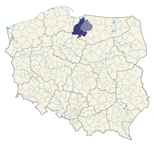
Polski: Powiśle na mapie administracyjnej Polski Kolorem jasnozielonym zaznaczono obszar Powiśla przed 1945 r. (tzw. rejencji zachodniopruskiej), zaś kolorem morskim – obszar, który również zaczęto zaliczać do Powiśla po 1945 r.
English: Powiśle on administrative map of Poland The light green colour indicates the area of Powisle before 1945 (the so-called West Prussian Regency), while the sea colour indicates the area that also started to be included in Powisle after 1945. |
||
| Date | |||
| Source |
This W3C-unspecified vector image was created with Inkscape . |
||
| Author | JakaśKreatywnaNazwa123 | ||
| Permission (Reusing this file) |
|
File history
Click on a date/time to view the file as it appeared at that time.
| Date/Time | Thumbnail | Dimensions | User | Comment | |
|---|---|---|---|---|---|
| current | 19:28, 3 May 2023 | | 6,331 × 6,047 (2.56 MB) | JakaśKreatywnaNazwa | Kolorystyka i poprawa granic |
| 18:56, 24 August 2022 |  | 5,935 × 5,669 (2.68 MB) | JakaśKreatywnaNazwa | Kolorystyka | |
| 16:49, 24 August 2022 |  | 5,935 × 5,669 (2.68 MB) | JakaśKreatywnaNazwa | Uploaded own work with UploadWizard |
File usage
The following pages on the English Wikipedia use this file (pages on other projects are not listed):
Global file usage
The following other wikis use this file:
- Usage on pl.wikipedia.org
- Usage on pl.wikivoyage.org
- Usage on www.wikidata.org