.png)
.png&action=edit&redlink=1)
No higher resolution available.
Political_Regions_of_Sudan_(CPA).png (511 × 600 pixels, file size: 79 KB, MIME type: image/png)
| This is a file from the Wikimedia Commons. Information from its description page there is shown below. Commons is a freely licensed media file repository. You can help. |
.png)
| Description |
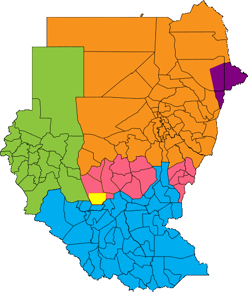
English: Map showing political regions of Sudan according to Protocol of Comprehensive Peace Agreement.
Darfur
Nuba Mountains and Blue Nile
North Sudan
South Sudan
Eastern Front, area of operations July 2006
Abyei, as defined by the Permanent Court of Arbitration |
| Date | |
| Source |
|
| Author | Сержант Кандыба |
| Permission (Reusing this file) |
This file is licensed under the Creative Commons Attribution-Share Alike 2.5 Generic license. Attribution: Сержант Кандыба
|
File history
Click on a date/time to view the file as it appeared at that time.
| Date/Time | Thumbnail | Dimensions | User | Comment | |
|---|---|---|---|---|---|
| current | 07:07, 15 January 2011 | | 511 × 600 (79 KB) | Сержант Кандыба | {{Information |Description={{en|1={{Information |Description={{en|Map showing political regions of Sudan according to Protocol of Comprehensive Peace Agreement.}} {{legend|#8cc63f|Darfur}} {{legend|#fb6282|Nuba Mountains and Blue Nile}} {{legend|#f7931d|N |
File usage
The following pages on the English Wikipedia use this file (pages on other projects are not listed):
Global file usage
The following other wikis use this file:
- Usage on de.wikipedia.org
.png)