Original file (2,000 × 1,414 pixels, file size: 1.13 MB, MIME type: image/jpeg)
| This is a file from the Wikimedia Commons. Information from its description page there is shown below. Commons is a freely licensed media file repository. You can help. |
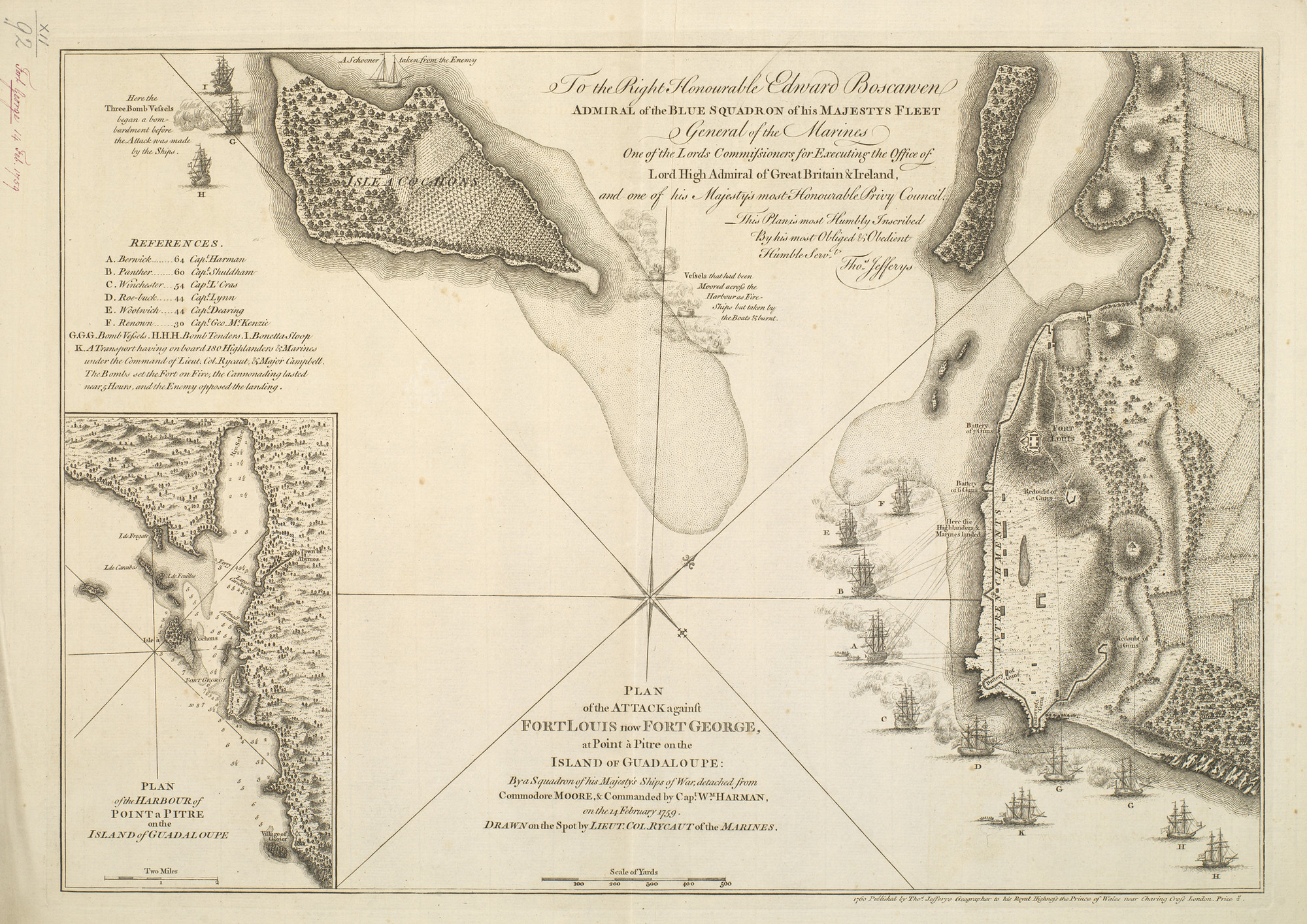
Summary
| PLAN of the ATTACK against FORT LOUIS now FORT GEORGE, at Point à Pitre on the / ISLAND of GUADALOUPE: By a Squadron of his Majesty’s Ships of War, detached from Commodore MOORE, & Commanded by Cap.t W.M HARMAN, on the 14 February 1759
( |
|||||||||||||||||||||||
|---|---|---|---|---|---|---|---|---|---|---|---|---|---|---|---|---|---|---|---|---|---|---|---|
| Author |
|
||||||||||||||||||||||
| Title |
PLAN of the ATTACK against FORT LOUIS now FORT GEORGE, at Point à Pitre on the / ISLAND of GUADALOUPE: By a Squadron of his Majesty’s Ships of War, detached from Commodore MOORE, & Commanded by Cap.t W.M HARMAN, on the 14 February 1759 |
||||||||||||||||||||||
| Description |
English: A map of the British naval attack on Fort Louis, Guadaloupe, 14 February 1759. Seven Years War (1756-63). Oriented with north-west to top (compass rose).
The ships of war named in the key are Berwick, Panther, Renown, Roebuck, Winchester, Woolwich. Insets: [bottom left:] PLAN / of the HARBOUR of / POINT a PITRE / on the / ISLAND of GUADALOUPE. Scale: 1:73,200 approx. Scale bar: Two Miles [44 mm =]. Size: 18.1 x 20.3 cm (neatline). Dedication: [top centre:] To the Right Honourable Edward Boscawen / ADMIRAL of the BLUE SQUADRON of his MAJESTYS FLEET / General of the Marines / One of the Lords Commissioners for Executing the Office of / Lord High Admiral of Great Britain & Ireland, / and one of his Majesty’s most Honourable Privy Council, / This Plan is most Humbly Inscribed / By his most Obliged & Obedient / Humble Serv.t / Tho.s Jefferys. Additional text: [left, a key to the names of the ships depicted, A-I, K:] REFERENCES. Annotations:Fort George 14 Feb. 1759. Other annotations: none. George III catalogue entry: George, Fort Plan of the attack against Fort Louis, now Fort George, at Point a Pitre on the Island of Guadaloupe, by a Squadron of His Majesty’s Ships of War detached from Commodore Moore, and commanded by Captain W.m Harman, on the 14.th of Feb.y 1759: by Lieut Col.l Rycaut RM: published by Jefferys, 1760. |
||||||||||||||||||||||
| Depicted place | Pointe-à-Pitre, Guadeloupe (16°14'31"N 61°32'03"W) | ||||||||||||||||||||||
| Date | 1760 | ||||||||||||||||||||||
| Medium | etching and engraving | ||||||||||||||||||||||
| Dimensions | Scale: 1:6,500 approx. Scale bar: Scale of Yards 500 [70 mm =]; 32.0 x 45.8 cm (neatline); 32.8 x 46.1 cm (image); 33.6 x 47.0 cm (platemark); 37.0 x 51.1 cm (sheet) | ||||||||||||||||||||||
| Collection |
|
||||||||||||||||||||||
| Accession number |
RCIN 732092 |
||||||||||||||||||||||
| Source/Photographer | https://militarymaps.rct.uk/the-seven-years-war-1756-63/pointe-a-pitre-1759-plan-of-the-attack-against-fort | ||||||||||||||||||||||
| Other versions |
|
||||||||||||||||||||||

.jpg)
Licensing
|
This is a faithful photographic reproduction of a two-dimensional, public domain work of art. The work of art itself is in the public domain for the following reason:
The official position taken by the Wikimedia Foundation is that "faithful reproductions of two-dimensional public domain works of art are public domain".
This photographic reproduction is therefore also considered to be in the public domain in the United States. In other jurisdictions, re-use of this content may be restricted; see Reuse of PD-Art photographs for details. | ||||
File history
Click on a date/time to view the file as it appeared at that time.
| Date/Time | Thumbnail | Dimensions | User | Comment | |
|---|---|---|---|---|---|
| current | 13:23, 18 July 2021 | | 2,000 × 1,414 (1.13 MB) | Broichmore | Uploaded a work by {{Creator:Thomas Jefferys}} Edward Rycaut (d. 1763) (surveyor) from https://militarymaps.rct.uk/the-seven-years-war-1756-63/pointe-a-pitre-1759-plan-of-the-attack-against-fort with UploadWizard |