
Size of this preview: 465 × 600 pixels. Other resolutions: 186 × 240 pixels | 510 × 658 pixels.
Original file (510 × 658 pixels, file size: 121 KB, MIME type: image/jpeg)
| This is a file from the Wikimedia Commons. Information from its description page there is shown below. Commons is a freely licensed media file repository. You can help. |
Summary
| Description |
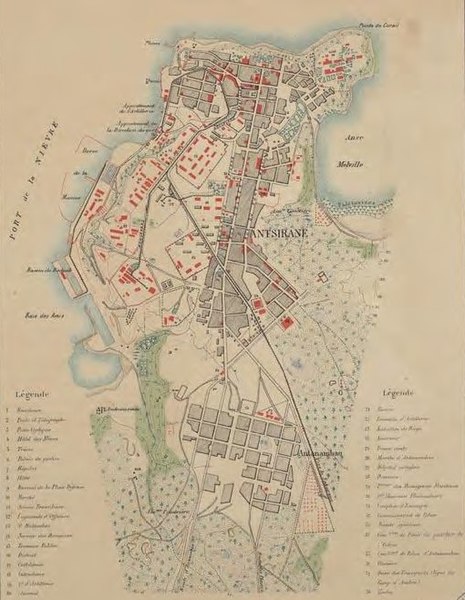
Français : Plan d’Antsirane datant de 1912 |
| Date | |
| Source | |
| Author |
|
| Other versions |

Licensing
|
This work is in the public domain in its country of origin and other countries and areas where the copyright term is the author's life plus 70 years or fewer. This work is in the public domain in the United States because it was published (or registered with the U.S. Copyright Office) before January 1, 1929. | |
| This file has been identified as being free of known restrictions under copyright law, including all related and neighboring rights. | |
This work was first published in Madagascar and is now in the public domain because its copyright protection has expired by virtue of the Law No. 94-036 of 18 September 1995 on Literary and Artistic Property (details). The work meets one of the following criteria:
|
 |
File history
Click on a date/time to view the file as it appeared at that time.
| Date/Time | Thumbnail | Dimensions | User | Comment | |
|---|---|---|---|---|---|
| current | 16:31, 25 February 2019 | | 510 × 658 (121 KB) | NearEMPTiness | =={{int:filedesc}}== {{Information |description={{fr|1=Plan d’Antsirane datant de 1912}} |date=1912 |source=* https://imageo.hypotheses.org/49 * http://geographie.ipt.univ-paris8.fr/rubriks/carto/journalGR/photos/ExpoDiegoAmelot.pdf |author=*Date de publication : 1912 *Auteurs(s) : Carbonnier *Éditeur : Service géographique de Madagascar (Tananarive) *Echelle : 1 / 10 000 *Format : 1 carte en couleur, 47 x 32 cm *Collection : Cartothèque du Département de Géographie, Service Commun de Documen... |
File usage
The following pages on the English Wikipedia use this file (pages on other projects are not listed):
Global file usage
The following other wikis use this file:
- Usage on de.wikipedia.org
- Usage on www.wikidata.org