
Size of this preview: 416 × 599 pixels. Other resolutions: 167 × 240 pixels | 333 × 480 pixels | 700 × 1,008 pixels.
Original file (700 × 1,008 pixels, file size: 181 KB, MIME type: image/png)
| This is a file from the Wikimedia Commons. Information from its description page there is shown below. Commons is a freely licensed media file repository. You can help. |
Summary
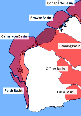
| Description | Approximate locations only. shape and size of basins determined by visual inspection of map on page 4 of Energy of Australia 2008 published by the Australian Bureau of Agricultural and Resource Economics (http://abare.gov.au/publications_html/energy/energy_08/energy_08.html) |
| Date | |
| Source | Own work by uploader, using public domain blank map of Australia as template |
| Author | Glen Dillon |
Licensing
I, the copyright holder of this work, hereby publish it under the following licenses:
This file is licensed under the Creative Commons Attribution-Share Alike 3.0 Unported license.
- You are free:
- to share – to copy, distribute and transmit the work
- to remix – to adapt the work
- Under the following conditions:
- attribution – You must give appropriate credit, provide a link to the license, and indicate if changes were made. You may do so in any reasonable manner, but not in any way that suggests the licensor endorses you or your use.
- share alike – If you remix, transform, or build upon the material, you must distribute your contributions under the same or compatible license as the original.

|
Permission is granted to copy, distribute and/or modify this document under the terms of the GNU Free Documentation License, Version 1.2 or any later version published by the Free Software Foundation; with no Invariant Sections, no Front-Cover Texts, and no Back-Cover Texts. A copy of the license is included in the section entitled GNU Free Documentation License. |
You may select the license of your choice.
File history
Click on a date/time to view the file as it appeared at that time.
| Date/Time | Thumbnail | Dimensions | User | Comment | |
|---|---|---|---|---|---|
| current | 12:29, 29 September 2008 | | 700 × 1,008 (181 KB) | Glen Dillon | {{Information |Description=Approximate locations only. shape and size of basins determined by visual inspection of map on page 4 of Energy of Australia 2008 published by the Australian Bureau of Agricultural and Resource Economics (http://abare.gov.au/pub |
| 04:59, 22 September 2008 |  | 720 × 1,040 (209 KB) | Glen Dillon | {{Information |Description=Approximate locations only. shape and size of basins determined by visual inspection of map in http://www.doir.wa.gov.au/documents/071399_Petroleum_Exp.pdf |Source=Own work by uploader, using public domain blank map of Australia | |
| 15:21, 18 September 2008 |  | 720 × 1,040 (229 KB) | Glen Dillon | {{Information |Description={{en|1=Approximate locations only. shape and size of basins determined by visual inspection of map on page 4 of Energy of Australia 2008 published by the Australian Bureau of Agricultural and Resource Economics}} |Source=Own wor |
File usage
The following pages on the English Wikipedia use this file (pages on other projects are not listed):
Global file usage
The following other wikis use this file:
- Usage on ar.wikipedia.org
- Usage on fr.wikipedia.org