Size of this preview: 800 × 593 pixels. Other resolutions: 320 × 237 pixels | 640 × 475 pixels | 1,024 × 759 pixels | 1,280 × 949 pixels | 2,481 × 1,840 pixels.
Original file (2,481 × 1,840 pixels, file size: 612 KB, MIME type: image/png)
| This is a file from the Wikimedia Commons. Information from its description page there is shown below. Commons is a freely licensed media file repository. You can help. |
Summary
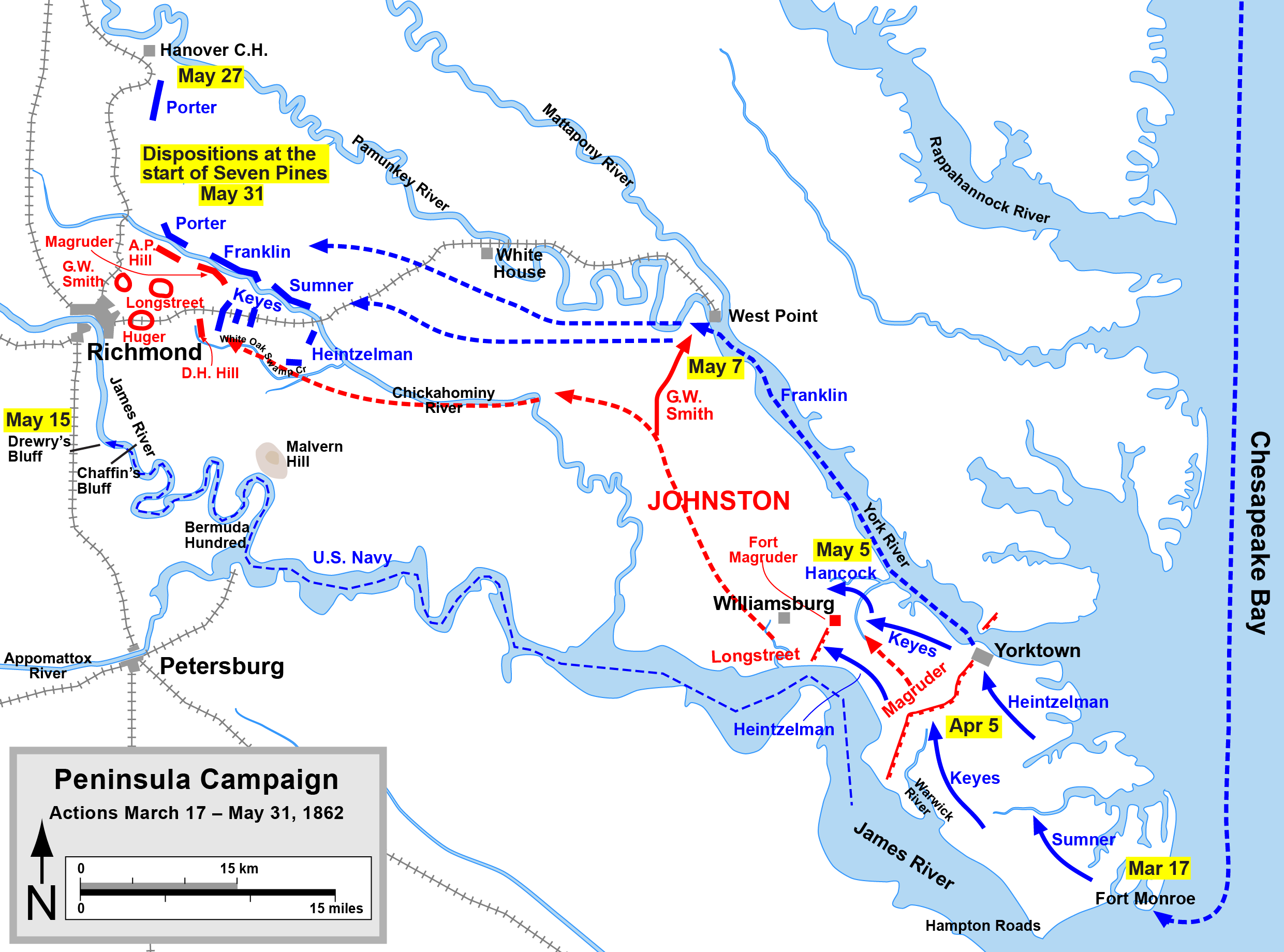
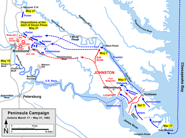
| Description | Map of the Peninsula Campaign of the American Civil War. Drawn in Adobe Illustrator CS5 by Hal Jespersen. Graphic source file is available at http://www.posix.com/CWmaps/ |
| Date | |
| Source | Own work |
| Author | Hal Jespersen |
This file is licensed under the Creative Commons Attribution 3.0 Unported license.
Attribution: Map by Hal Jespersen, www.posix.com/CW
- You are free:
- to share – to copy, distribute and transmit the work
- to remix – to adapt the work
- Under the following conditions:
- attribution – You must give appropriate credit, provide a link to the license, and indicate if changes were made. You may do so in any reasonable manner, but not in any way that suggests the licensor endorses you or your use.
File history
Click on a date/time to view the file as it appeared at that time.
| Date/Time | Thumbnail | Dimensions | User | Comment | |
|---|---|---|---|---|---|
| current | 16:05, 24 April 2011 | | 2,481 × 1,840 (612 KB) | Hlj | Update to more recent graphical format of rivers and roads. Same license. |
| 23:11, 24 November 2010 |  | 2,481 × 1,840 (405 KB) | Hlj | Updated graphical formats to conform to more recent American Civil War map conventions, added legend and scale. | |
| 22:12, 28 April 2006 |  | 2,381 × 1,753 (512 KB) | Thuresson | Map of the Peninsula Campaign of the American Civil War, up to Seven Pines. Drawn by Hal Jespersen in Macromedia Freehand. Graphic source file is available at http://www.posix.com/CWmaps/ Image history of en:Image:PeninsulaCampaign.png: (del) ( |
File usage
No pages on the English Wikipedia use this file (pages on other projects are not listed).
Global file usage
The following other wikis use this file:
- Usage on da.wikipedia.org
- Usage on de.wikipedia.org
- Usage on fr.wikipedia.org
- Usage on it.wikipedia.org
- Usage on ja.wikipedia.org
- Usage on ko.wikipedia.org
- Usage on nl.wikipedia.org
- Usage on no.wikipedia.org
- Usage on pl.wikipedia.org
- Usage on ru.wikipedia.org