
Size of this preview: 800 × 477 pixels. Other resolutions: 320 × 191 pixels | 640 × 381 pixels | 1,024 × 610 pixels | 1,280 × 762 pixels | 2,560 × 1,525 pixels | 4,721 × 2,812 pixels.
Original file (4,721 × 2,812 pixels, file size: 7.57 MB, MIME type: image/jpeg)
| This is a file from the Wikimedia Commons. Information from its description page there is shown below. Commons is a freely licensed media file repository. You can help. |
Summary
| Description |
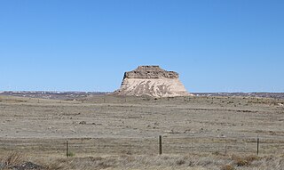
English: One of the two buttes that make up the Pawnee Buttes, located in the Pawnee National Grassland in Weld County, Colorado. Part of the Cedar Creek Wind Farm can be seen in the distance. |
| Date | |
| Source | Own work |
| Author | Jeffrey Beall |
| Camera location | | View this and other nearby images on: OpenStreetMap |
|---|
Licensing
I, the copyright holder of this work, hereby publish it under the following license:
This file is licensed under the Creative Commons Attribution 3.0 Unported license.
- You are free:
- to share – to copy, distribute and transmit the work
- to remix – to adapt the work
- Under the following conditions:
- attribution – You must give appropriate credit, provide a link to the license, and indicate if changes were made. You may do so in any reasonable manner, but not in any way that suggests the licensor endorses you or your use.
File history
Click on a date/time to view the file as it appeared at that time.
| Date/Time | Thumbnail | Dimensions | User | Comment | |
|---|---|---|---|---|---|
| current | 11:05, 1 April 2016 | | 4,721 × 2,812 (7.57 MB) | Jeffrey Beall | {{Information |Description ={{en|1=One of the two buttes that make up the Pawnee Buttes, located in the Pawnee National Grassland in Weld County, Colorado.}} |Source ={{own}} |Author =Jeffrey Beall |Date... |
File usage
The following pages on the English Wikipedia use this file (pages on other projects are not listed):
Global file usage
The following other wikis use this file:
- Usage on fr.wikipedia.org
- Usage on www.wikidata.org