
Original file (932 × 720 pixels, file size: 129 KB, MIME type: image/jpeg)
| This is a file from the Wikimedia Commons. Information from its description page there is shown below. Commons is a freely licensed media file repository. You can help. |
Summary
| Description |
English: 09.27.2012
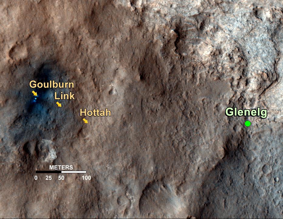
Curiosity's Roadside Discoveries This map shows the path on Mars of NASA's Curiosity rover toward Glenelg, an area where three terrains of scientific interest converge. Arrows mark geological features encountered so far that led to the discovery of what appears to be an ancient Martian streambed. The first site, dubbed Goulburn, is an area where the thrusters from the rover's descent stage blasted away a layer of loose material, exposing bedrock underneath. Goulburn gave scientists a hint that water might have transported the pebbly sandstone material making up the outcrop. The second feature, a naturally exposed rock outcrop named Link, stood out to the science team for its embedded, rounded gravel pieces. Such rounded shapes are strong evidence of water transport. The final feature, another naturally exposed rock outcrop named Hottah, offered the most compelling evidence yet of an ancient stream, as it contains abundant rounded pebbles. The grain sizes are also an important part of the evidence for water: the rounded pebbles, which are up to 1.6 inches (4 centimeters) in size, are too large to have been transported by wind. The image used for the map is from an observation of the landing site by the High Resolution Imaging Science Experiment (HiRISE) instrument on NASA's Mars Reconnaissance Orbiter.Polski: Odkrycia łazika Curiosity
Image Credit: NASA/JPL-Caltech/Univ. of ArizonaMapa pokazuje trasę po powierzchni Marsa, należącego do NASA łazika Curiosity, do obszaru Glenelg, na którym to obszarze, z naukowego punktu zainteresowania, zbiegają się trzy różne tereny. Strzałki wskazują napotkane do tej pory miejsca, których geologiczne cechy, doprowadziły do odkrycia czegoś, co wydaje się być dawnym marsjańskim potokiem. Pierwsze miejsce, nazwane Goulburn, jest obszarem, w którym silniki członu zniżania łazika odrzuciły warstwę luźnego materiału, odsłaniając podłoże skalne. Goulburn dał naukowcom wskazówkę, że woda może transportować kamienie piaskowca, z którego to materiału składa się odkrywka. Inne miejsce, naturalnie odkryte podłoże skalne nazwane Link, zwracające uwagę zespołu naukowego, ze względu na osadzone w nim owalne konglomeraty żwiru. Takie zaokrąglone kształty są mocnymi dowodami transportu siłą nurtu wody. Ostatni dowód, inne naturalnie odkryte podłoże skalne nazwane Hottah, zaproponował bardziej przekonujące dowody istnienia w przeszłości strumienia, ponieważ zawiera liczne zaokrąglone kamyki. Wielkości ziaren są również ważną częścią dowodów na istnienie nurtu wody: zaokrąglone kamyki, które mają średnicę do 4 cm, są zbyt duże, aby mogłyby być transportowane przez wiatr. Obraz użyty do wykonania mapy pochodzi z obserwacji lądowiska przez teleskop zwierciadlany HiRISE instrument znajdujący się na pokładzie należącego NASA do orbitera Mars Reconnaissance Orbiter. Mapka posiada adnotację wskazującą położenie miejsca lądowania nazywane Bradbury Landing. Kliknij aby adnotację uruchomić. |
| Date | |
| Source | http://photojournal.jpl.nasa.gov/jpeg/PIA16157.jpg |
| Author | NASA/JPL-Caltech/Univ. of Arizona |
| Other versions | http://photojournal.jpl.nasa.gov/catalog/PIA16157 |
Licensing
| This file is in the public domain in the United States because it was solely created by NASA. NASA copyright policy states that "NASA material is not protected by copyright unless noted". (See Template:PD-USGov, NASA copyright policy page or JPL Image Use Policy.) | ||
 |
Warnings:
|
| Annotations | This image is annotated: View the annotations at Commons |
File history
Click on a date/time to view the file as it appeared at that time.
| Date/Time | Thumbnail | Dimensions | User | Comment | |
|---|---|---|---|---|---|
| current | 17:32, 5 October 2012 | | 932 × 720 (129 KB) | Drbogdan | User created page with UploadWizard |
File usage
Global file usage
The following other wikis use this file:
- Usage on es.wikipedia.org
- Usage on pl.wikipedia.org
- Usage on ru.wikipedia.org
- Usage on uk.wikipedia.org
- Usage on zh.wikipedia.org