No higher resolution available.
Operation_frantic_map.png (750 × 564 pixels, file size: 167 KB, MIME type: image/png)
| This is a file from the Wikimedia Commons. Information from its description page there is shown below. Commons is a freely licensed media file repository. You can help. |
Summary
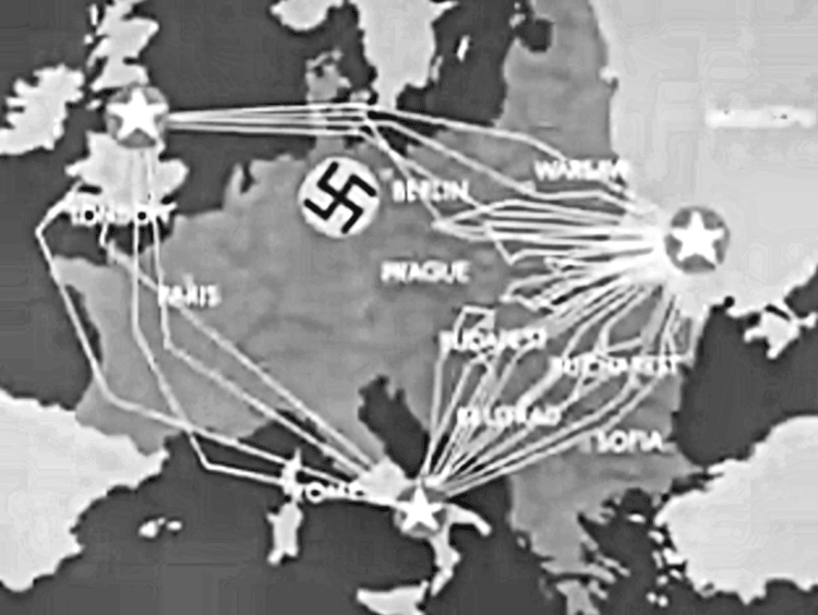
| Description |
English: Frame shot of routes taken by USAAF strategic bombers during "Operation Frantic", the shuttle bombing missions between England, Italy and the Soviet Union, 1944. |
| Date | |
| Source | Operation Titanic, United States War Department Film, Produced by the Army Pictorial Service (Signal Corps), in conjunction with the Army Air Forces, 1945 |
| Author | United States War Department |
| Permission (Reusing this file) |
USGOV-PD |
Licensing
This image or file is a work of a U.S. Air Force Airman or employee, taken or made as part of that person's official duties. As a work of the U.S. federal government, the image or file is in the public domain in the United States.
|
 |
File history
Click on a date/time to view the file as it appeared at that time.
| Date/Time | Thumbnail | Dimensions | User | Comment | |
|---|---|---|---|---|---|
| current | 15:28, 13 April 2011 | | 750 × 564 (167 KB) | SamOdin | small fix |
| 16:44, 29 April 2010 |  | 750 × 564 (175 KB) | Bwmoll3 | {{Information |Description={{en|1=Frame shot of routes taken by USAAF strategic bombers during "Operation Frantic", the shuttle bombing missions between England, Italy and the Soviet Union, 1944.}} |Source=Operation Titanic, United States War Department |
File usage
The following pages on the English Wikipedia use this file (pages on other projects are not listed):
Global file usage
The following other wikis use this file:
- Usage on de.wikipedia.org
- Usage on fr.wikipedia.org
- Usage on he.wikipedia.org
- Usage on id.wikipedia.org
- Usage on ro.wikipedia.org
- Usage on ru.wikipedia.org
- Usage on uk.wikipedia.org
- Usage on www.wikidata.org