File:Olivenca Portalegre Evora.png

Olivenca_Portalegre_Evora.png (459 × 498 pixels, file size: 18 KB, MIME type: image/png)

Description
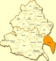
English: Unofficial map of the Portuguese parish of Olivença, illegitimately annexed by Spain in 1801.
Español: Mapa de los actuales distritos portugueses de Portalegre y Évora junto al territorio portugués de Olivença, no legítimamente anexionada por España en 1801.
Source Original File
Author Júlio Reis (User:Tintazul)
Permission
(Reusing this file)
w:en:Creative Commons
attribution share alike
This file is licensed under the Creative Commons Attribution-Share Alike 2.5 Generic license.
You are free:
  • to share – to copy, distribute and transmit the work
  • to remix – to adapt the work
Under the following conditions:
  • attribution – You must give appropriate credit, provide a link to the license, and indicate if changes were made. You may do so in any reasonable manner, but not in any way that suggests the licensor endorses you or your use.
  • share alike – If you remix, transform, or build upon the material, you must distribute your contributions under the same or compatible license as the original.

Captions

This map of Evora district shows the Portuguese city of Olivença, which was illegitimately occupied by Spain, who refuses to return it to Portugal.

Items portrayed in this file

depicts

image/png

File history

Click on a date/time to view the file as it appeared at that time.

Date/TimeThumbnailDimensionsUserComment
current08:57, 12 September 2005Thumbnail for version as of 08:57, 12 September 2005459 × 498 (18 KB)Tintazul{{Information| |Description=Map of Olivença ('''es:''' Olivenza), annexed by Spain in 1801, next to present-day municipalities in the Portalegre and Évora districts, Portugal. |Source=Original File |Date= |Author=Júlio Reis (User:Tintazul) |Permiss

The following page uses this file:

Global file usage

The following other wikis use this file: