
No higher resolution available.
Oldwinderbuilding.jpg (566 × 452 pixels, file size: 190 KB, MIME type: image/jpeg)
| This is a file from the Wikimedia Commons. Information from its description page there is shown below. Commons is a freely licensed media file repository. You can help. |
Summary
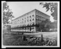
| English: Old Winder Building, 17th St., N.W., below Pa. Ave., Washington, D.C. | |||
|---|---|---|---|
| Author |
Brady-Handy Photograph Collection (Library of Congress). |
||
| Title |
English: Old Winder Building, 17th St., N.W., below Pa. Ave., Washington, D.C. |
||
| Description |
English: Old Winder Building, 17th St., N.W., below Pa. Ave., Washington, D.C. |
||
| Date | between 1860 and 1880 | ||
| Accession number |
LC-USZ62-135530 (b&w film copy neg.) Call Number: LOT 12668 [item] [P&P] |
||
| Source |
|
||
| Permission (Reusing this file) |
Rights Advisory: No known restrictions on publication. | ||
| Other versions |
|
||

| Object location | | View this and other nearby images on: OpenStreetMap |
|---|
Licensing
| This work is from the Brady-Handy collection at the Library of Congress. According to the library, there are no known copyright restrictions on the use of this work. Mathew Brady died in 1896 and Levin C. Handy died in 1932. Photographs in this collection are in the public domain in the United States as works published before 1929 or as unpublished works whose copyright term has expired (life of author + 70 years).
|
 |
File history
Click on a date/time to view the file as it appeared at that time.
| Date/Time | Thumbnail | Dimensions | User | Comment | |
|---|---|---|---|---|---|
| current | 21:03, 6 October 2012 | | 566 × 452 (190 KB) | Slowking4 | Reverted to version as of 21:01, 6 October 2012 |
| 21:02, 6 October 2012 |  | 566 × 452 (190 KB) | Slowking4 | crop again | |
| 21:01, 6 October 2012 |  | 566 × 452 (190 KB) | Slowking4 | crop | |
| 14:22, 27 September 2012 |  | 640 × 520 (73 KB) | Slowking4 | User created page with UploadWizard |
File usage
The following pages on the English Wikipedia use this file (pages on other projects are not listed):