No higher resolution available.
Oklahoma_3.0_earthquake_graph_2014-05-02.gif (450 × 342 pixels, file size: 10 KB, MIME type: image/gif, 0.1 s)
| This is a file from the Wikimedia Commons. Information from its description page there is shown below. Commons is a freely licensed media file repository. You can help. |
Summary
| Description |
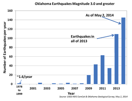
English: Graph from the servers of the United States Geological Survey – The graph depicts the extremely significant increase in annual total of earthquakes in Oklahoma of greater than or equal to magnitude 3.0 on the moment magnitude scale. The graph was released along with the first-ever advisory for damaging earthquakes issued for an area of of the Rocky Mountains, warning of an elevated probability of a damaging earthquake of 5.5+ magnitude. The graph was created using information from the United States Geological Survey and the Oklahoma Geological Survey. |
|||
| Date | ||||
| Source | https://earthquake.usgs.gov/regional/ceus/products/newsrelease_05022014.php | |||
| Author | United States Geological Survey, Oklahoma Geological Survey | |||
| Permission (Reusing this file) |
Licensing
|
File history
Click on a date/time to view the file as it appeared at that time.
| Date/Time | Thumbnail | Dimensions | User | Comment | |
|---|---|---|---|---|---|
| current | 15:18, 28 June 2014 | | 450 × 342 (10 KB) | Master of Time | User created page with UploadWizard |
File usage
No pages on the English Wikipedia use this file (pages on other projects are not listed).