
Size of this preview: 800 × 409 pixels. Other resolutions: 320 × 163 pixels | 640 × 327 pixels | 1,400 × 715 pixels.
Original file (1,400 × 715 pixels, file size: 151 KB, MIME type: image/png)
| This is a file from the Wikimedia Commons. Information from its description page there is shown below. Commons is a freely licensed media file repository. You can help. |
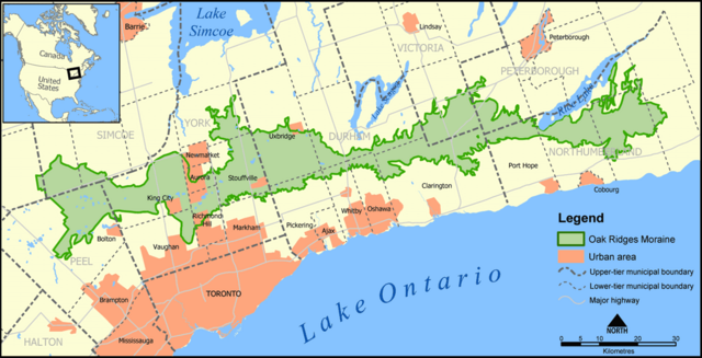
A map showing the Oak Ridges Moraine in southern Ontario, Canada.
Created by NormanEinstein, May 27, 2005.
| I, the copyright holder of this work, release this work into the public domain. This applies worldwide. In some countries this may not be legally possible; if so: I grant anyone the right to use this work for any purpose, without any conditions, unless such conditions are required by law. |
File history
Click on a date/time to view the file as it appeared at that time.
| Date/Time | Thumbnail | Dimensions | User | Comment | |
|---|---|---|---|---|---|
| current | 14:17, 24 June 2005 | | 1,400 × 715 (151 KB) | NormanEinstein | Updated map. Added labels for Bolton and King City. |
| 20:12, 7 June 2005 |  | 1,400 × 716 (699 KB) | NormanEinstein | Doh. Forgot the highways on the last one. | |
| 21:18, 6 June 2005 |  | 1,400 × 715 (601 KB) | NormanEinstein | Tidied up a bit. | |
| 20:41, 27 May 2005 |  | 1,000 × 510 (377 KB) | NormanEinstein | A map showing the Oak Ridges Moraine in southern Ontario, Canada. Created by NormanEinstein, May 27, 2005. {{GFDL-self}} Category:Maps of Canada |
File usage
The following pages on the English Wikipedia use this file (pages on other projects are not listed):
Global file usage
The following other wikis use this file:
- Usage on fr.wikipedia.org
- Usage on zh-yue.wikipedia.org