.jpg)
.jpg&action=edit&redlink=1)

Original file (1,024 × 683 pixels, file size: 1.06 MB, MIME type: image/jpeg)
| This is a file from the Wikimedia Commons. Information from its description page there is shown below. Commons is a freely licensed media file repository. You can help. |
.jpg)
Summary
| Description |
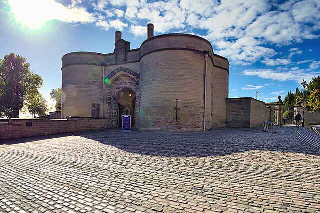
English: The Castle's original Norman construction began in 1068 and was added to extensively through the Medieval period. It was an important royal fortress and occasional royal residence during the Middle Ages. The site occupies a commanding position on a natural promontory known as "Castle Rock", with cliffs 130 feet high to the south and west which dominates the city skyline.
The original Castle was largely demolished in 1651, after the Civil War and it was replaced by a Stuart Restoration-era ducal palace in the 1670s. This was renovated in the 1870s to house an art gallery and museum, which remain in use. Little of the original castle survives other than the gatehouse and parts of the ramparts, but sufficient portions remain to give an impression of the layout of the site and it is protected as a Scheduled Ancient Monument (List Entry 1006382 Historic England). The gatehouse was built for Henry III in the 1250s. The gatehouse of the medieval castle and much of the walling of the outer bailey were retained as a garden wall for the Ducal Mansion. It was restored and a gateway was added in 1908. It is an important survivor of the medieval castle and is Listed as a Grade I listed building (List Entry 1247094 Historic England). Although the castle is owned by Nottingham City Council, it is operated by an independent charitable trust called the Nottingham Castle Trust. |
| Date | |
| Source | From geograph.org.uk |
| Author | David Dixon |
| Permission (Reusing this file) |
Creative Commons Attribution Share-alike license 2.0 |
| Attribution (required by the license) | David Dixon / Nottingham Castle Gatehouse / |
| Camera location | | View this and other nearby images on: OpenStreetMap |
|---|
.jpg¶ms=052.950838_N_-001.153705_E_globe:Earth_type:camera_source:geograph-osgb36(SK5695839608)_heading:202.00&language=en)
| Object location | | View this and other nearby images on: OpenStreetMap |
|---|
.jpg¶ms=052.950590_N_-001.153830_E_globe:Earth_class:object_type:object_source:geograph-osgb36(SK56953958)_heading:202.00&language=en)
Licensing

|
This image was taken from the Geograph project collection. See this photograph's page on the Geograph website for the photographer's contact details. The copyright on this image is owned by David Dixon and is licensed for reuse under the Creative Commons Attribution-ShareAlike 2.0 license.
|
- You are free:
- to share – to copy, distribute and transmit the work
- to remix – to adapt the work
- Under the following conditions:
- attribution – You must give appropriate credit, provide a link to the license, and indicate if changes were made. You may do so in any reasonable manner, but not in any way that suggests the licensor endorses you or your use.
- share alike – If you remix, transform, or build upon the material, you must distribute your contributions under the same or compatible license as the original.
File history
Click on a date/time to view the file as it appeared at that time.
| Date/Time | Thumbnail | Dimensions | User | Comment | |
|---|---|---|---|---|---|
| current | 18:48, 2 May 2023 | | 1,024 × 683 (1.06 MB) | Chocolateediter | == {{int:filedesc}} == {{Information |Description={{en|1=The Castle's original Norman construction began in 1068 and was added to extensively through the Medieval period. It was an important royal fortress and occasional royal residence during the Middle Ages. The site occupies a commanding position on a natural promontory known as "Castle Rock", with cliffs 130 feet high to the south and west which dominates the city skyline. The original Castle was largely demolished in 1651, after the Civ... |
.jpg)