No higher resolution available.
NewZealandAirportsMap.png (502 × 494 pixels, file size: 38 KB, MIME type: image/png)
| This is a file from the Wikimedia Commons. Information from its description page there is shown below. Commons is a freely licensed media file repository. You can help. |
Summary
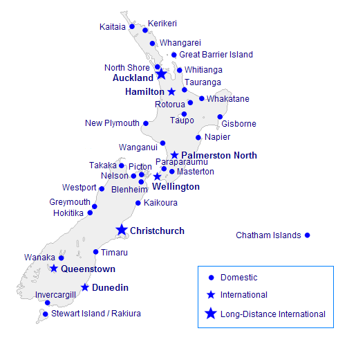
| Description | Map showing various airports in New Zealand. State January 2006. |
| Date | 22 January 2006 (original upload date) |
| Source | No machine-readable source provided. Own work assumed (based on copyright claims). |
| Author | No machine-readable author provided. Vardion assumed (based on copyright claims). |
Licensing
| I, the copyright holder of this work, release this work into the public domain. This applies worldwide. In some countries this may not be legally possible; if so: I grant anyone the right to use this work for any purpose, without any conditions, unless such conditions are required by law. |
File history
Click on a date/time to view the file as it appeared at that time.
| Date/Time | Thumbnail | Dimensions | User | Comment | |
|---|---|---|---|---|---|
| current | 19:53, 22 January 2006 | | 502 × 494 (38 KB) | Vardion | adding Greymouth |
| 03:16, 22 January 2006 |  | 502 × 494 (38 KB) | Vardion | more airports | |
| 00:59, 22 January 2006 |  | 502 × 494 (36 KB) | Vardion | adding Picton | |
| 00:48, 22 January 2006 |  | 502 × 494 (37 KB) | Vardion | adding Kaikoura | |
| 00:37, 22 January 2006 |  | 502 × 494 (37 KB) | Vardion | forgot to label Wanganui | |
| 00:34, 22 January 2006 |  | 502 × 494 (36 KB) | Vardion | map showing airports in New Zealand |
File usage
The following pages on the English Wikipedia use this file (pages on other projects are not listed):
Global file usage
The following other wikis use this file:
- Usage on de.wikipedia.org
- Usage on fa.wikipedia.org
- Usage on fr.wikipedia.org
- Usage on ja.wikipedia.org
- Usage on ru.wikipedia.org
- Usage on zh.wikipedia.org