
Size of this preview: 730 × 599 pixels. Other resolutions: 292 × 240 pixels | 585 × 480 pixels | 936 × 768 pixels | 1,248 × 1,024 pixels | 1,284 × 1,054 pixels.
Original file (1,284 × 1,054 pixels, file size: 164 KB, MIME type: image/jpeg)
| This is a file from the Wikimedia Commons. Information from its description page there is shown below. Commons is a freely licensed media file repository. You can help. |
Summary
| Description |
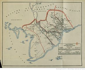
Tiếng Việt: Bản đồ Nam Kỳ Lục Tỉnh (Basse CochinChine) nhà Nguyễn thời độc lập trước năm 1861. Đường biên giới giữa Vương quốc Campuchia của người Khmer với Nam Kỳ Lục Tỉnh (Frontiére du Royaume de Cambodge de Khmere de la Basse CochinChine), chạy song song cách xa kênh Vĩnh Tế với một vùng đất nằm kẹp ở giữa, và bao vùng lồi Svay Rieng trong phần lãnh thổ Nam Kỳ Lục Tỉnh. |
| Date | |
| Source | http://gallica.bnf.fr/ark:/12148/bpt6k58483061/f51.zoom |
| Author | Victor Duvernoy |
Licensing
|
This work is in the public domain in its country of origin and other countries and areas where the copyright term is the author's life plus 70 years or fewer. | |
| This file has been identified as being free of known restrictions under copyright law, including all related and neighboring rights. | |
File history
Click on a date/time to view the file as it appeared at that time.
| Date/Time | Thumbnail | Dimensions | User | Comment | |
|---|---|---|---|---|---|
| current | 07:52, 24 November 2012 | | 1,284 × 1,054 (164 KB) | Doãn Hiệu | User created page with UploadWizard |
File usage
The following pages on the English Wikipedia use this file (pages on other projects are not listed):
Global file usage
The following other wikis use this file:
- Usage on de.wikipedia.org
- Usage on fr.wikipedia.org
- Usage on ro.wikipedia.org
- Usage on uk.wikipedia.org
- Usage on vi.wikipedia.org