
Size of this preview: 700 × 599 pixels. Other resolutions: 280 × 240 pixels | 561 × 480 pixels | 897 × 768 pixels | 1,196 × 1,024 pixels | 2,284 × 1,956 pixels.
Original file (2,284 × 1,956 pixels, file size: 4.95 MB, MIME type: image/png)
| This is a file from the Wikimedia Commons. Information from its description page there is shown below. Commons is a freely licensed media file repository. You can help. |
Summary
| Description |
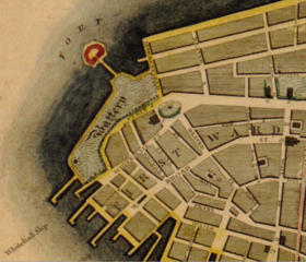
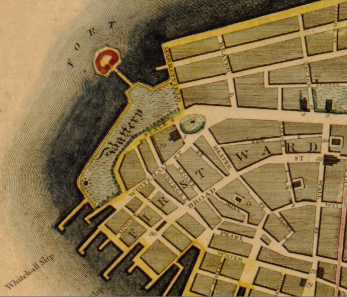
English: Closeup of Castle Clinton to Wall Street in 1811 Manhattan from Map of the city of New York and island of Manhattan, as laid out by the commissioners appointed by the legislature, April 3d, 1807 from copy at LOC |
|||||||||
| Date | ||||||||||
| Source |
This map of the city of New York and island of Manhattan, as laid out by the commissioners appointed by the legislature, April 3d, 1807 is respectfully dedicated to the mayor, aldermen and commonalty thereof Copy 1 G3804.N4:2M3 1811 .B7 |
|||||||||
| Creator |
Bridges, William, -1814 Maverick, Peter, 1780-1831 |
|||||||||
| Geotemporal data | ||||||||||
| Bounding box |
|
|||||||||
| Georeferencing | ||||||||||

|
This map is available from the United States Library of Congress's Geography & Map Division
under the digital ID g3804n.ct000812. This tag does not indicate the copyright status of the attached work. A normal copyright tag is still required. See Commons:Licensing.
|
Licensing
|
This work is in the public domain in its country of origin and other countries and areas where the copyright term is the author's life plus 70 years or fewer. This work is in the public domain in the United States because it was published (or registered with the U.S. Copyright Office) before January 1, 1929. | |
| This file has been identified as being free of known restrictions under copyright law, including all related and neighboring rights. | |
File history
Click on a date/time to view the file as it appeared at that time.
| Date/Time | Thumbnail | Dimensions | User | Comment | |
|---|---|---|---|---|---|
| current | 12:39, 23 January 2022 | | 2,284 × 1,956 (4.95 MB) | DutchTreat | Uploaded a work by Bridges, William, -1814 Maverick, Peter, 1780-1831 from This map of the city of New York and island of Manhattan, as laid out by the commissioners appointed by the legislature, April 3d, 1807 is respectfully dedicated to the mayor, aldermen and commonalty thereof Copy 1 [https://www.loc.gov/resource/g3804n.ct000812 G3804.N4:2M3 1811 .B7] with UploadWizard |
File usage
The following pages on the English Wikipedia use this file (pages on other projects are not listed):