.jpg)
.jpg&action=edit&redlink=1)

Original file (4,000 × 6,000 pixels, file size: 25.62 MB, MIME type: image/jpeg)
| This is a file from the Wikimedia Commons. Information from its description page there is shown below. Commons is a freely licensed media file repository. You can help. |
.jpg)
Summary
| Description |
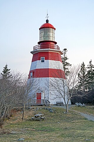
PLEASE, NO invitations or self promotions, THEY WILL BE DELETED. My photos are FREE to use, just give me credit and it would be nice if you let me know, thanks. When the communities of Cape Sable Island and Barrington learned that the lantern room and lens from the Seal Island Lighthouse were going to be removed in 1977 and relocated to the National Museum of Science and Technology in Ottawa, residents took steps to keep the artifacts in the area. Their efforts paid off, it was decided that the lens and lantern room would remain in Barrington, if the community could properly care for them. An approximately half-scale replica of the Seal Island Lighthouse was constructed as a base for the historic lantern room and second-order Fresnel lens. You can climb to the 1907 iron lantern which sits atop a replica of the original 1831 lighthouse on Seal Island. Inside the lantern visitors get a light keeper's view of the jewel-like second order Fresnel lens which was the lens from the original lighthouse. |
| Date | |
| Source | NS-00001 - Seal Island Lighthouse Museum |
| Author | Dennis Jarvis from Halifax, Canada |
| Camera location | | View this and other nearby images on: OpenStreetMap |
|---|
.jpg¶ms=043.569446_N_-065.575332_E_globe:Earth_type:camera_source:Flickr_&language=en)
Licensing
- You are free:
- to share – to copy, distribute and transmit the work
- to remix – to adapt the work
- Under the following conditions:
- attribution – You must give appropriate credit, provide a link to the license, and indicate if changes were made. You may do so in any reasonable manner, but not in any way that suggests the licensor endorses you or your use.
- share alike – If you remix, transform, or build upon the material, you must distribute your contributions under the same or compatible license as the original.
| This image was originally posted to Flickr by archer10 (Dennis) at https://flickr.com/photos/22490717@N02/41158742692. It was reviewed on 13 November 2020 by FlickreviewR 2 and was confirmed to be licensed under the terms of the cc-by-sa-2.0. |
File history
Click on a date/time to view the file as it appeared at that time.
| Date/Time | Thumbnail | Dimensions | User | Comment | |
|---|---|---|---|---|---|
| current | 11:22, 13 November 2020 | | 4,000 × 6,000 (25.62 MB) | JotaCartas | Transferred from Flickr via #flickr2commons |
File usage
Global file usage
The following other wikis use this file:
- Usage on fr.wikipedia.org
.jpg)