File:Morphometry of Concepcion Bank. Evidence of Geological and Biological Processes on a Large Volcanic Seamount of the Canary Islands Seamount Province. 2016 Rivera et al. Fig. 1.PNG

Original file(2,207 × 2,109 pixels, file size: 1.37 MB, MIME type: image/png)

Summary

Description
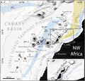
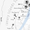
English: Fig 1. General bathymetric map of the Canary Islands Seamount Province (CISP).

Note the seamounts, islands and other relevant physiographic features as well as the regional surface current system. The Canary Basin, the Canary Ridge, the Canary Channel and its diapir belt extending northwards are indicated. Numbers attached to seamounts and islands represent individual oldest age estimate where available, after Van den Bogaard [28]. AC: Azores Current. CC: Canary Current. CUC: Canary Upwelling Current. NEC: North EquatorialCurrent. SV: Selvagens. L: Lanzarote. F: Fuerteventura. GC: Gran Canaria. TF: Tenerife. LP: La Palma. EH: El Hierro. Bathymetry in meters from GEBCO.

DOI: 10.1371/journal.pone.0156337
Date
Source Rivera, J. et al. (2016). "Morphometry of Concepcion Bank: Evidence of Geological and Biological Processes on a Large Volcanic Seamount of the Canary Islands Seamount Province". PLoS ONE 11 (5). DOI:10.1371/journal.pone.0156337. (Fig. 1: [1])
Author © 2016 Rivera et al
Permission
(Reusing this file)
w:en:Creative Commons
attribution
This file is licensed under the Creative Commons Attribution 4.0 International license.
You are free:
  • to share – to copy, distribute and transmit the work
  • to remix – to adapt the work
Under the following conditions:
  • attribution – You must give appropriate credit, provide a link to the license, and indicate if changes were made. You may do so in any reasonable manner, but not in any way that suggests the licensor endorses you or your use.
This file, which was originally posted to Rivera, J. et al. (2016). "Morphometry of Concepcion Bank: Evidence of Geological and Biological Processes on a Large Volcanic Seamount of the Canary Islands Seamount Province". PLoS ONE 11 (5). DOI:10.1371/journal.pone.0156337. (Fig. 1: [2]), was reviewed on 14 April 2018 by reviewer Leoboudv, who confirmed that it was available there under the stated license on that date.
Other versions

Captions

Add a one-line explanation of what this file represents

Items portrayed in this file

depicts

31 May 2016

File history

Click on a date/time to view the file as it appeared at that time.

Date/TimeThumbnailDimensionsUserComment
current05:37, 14 April 2018Thumbnail for version as of 05:37, 14 April 20182,207 × 2,109 (1.37 MB)Asqueladd== {{int:filedesc}} == {{Information |description={{en|1='''Fig 1. General bathymetric map of the Canary Islands Seamount Province (CISP).'''<br /><br />Note the seamounts, islands and other relevant physiographic features as well as the regional surface current system. The Canary Basin, the Canary Ridge, the Canary Channel and its diapir belt extending northwards are indicated. Numbers attached to seamounts and islands represent individual oldest age estimate where available, after Van den B...
The following pages on the English Wikipedia use this file (pages on other projects are not listed):

Global file usage

The following other wikis use this file:

Metadata