
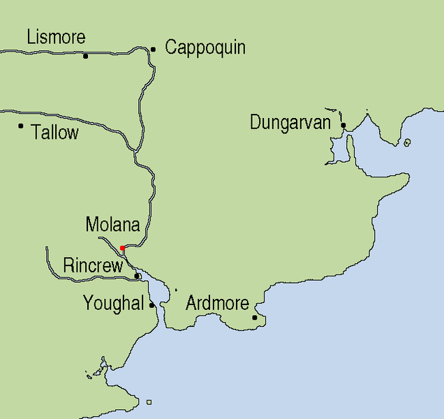
Size of this preview: 636 × 600 pixels. Other resolutions: 254 × 240 pixels | 509 × 480 pixels | 651 × 614 pixels.
Original file (651 × 614 pixels, file size: 13 KB, MIME type: image/png)
| This is a file from the Wikimedia Commons. Information from its description page there is shown below. Commons is a freely licensed media file repository. You can help. |
Summary
| Description | Map of the surrounding area of Molana Priory, County Waterford, Ireland |
| Date | |
| Source | This map is based on Image:Topography Ireland.jpg and my own work using Gimp and xfig. |
| Author | AFBorchert |
Please note that this is just a sketch to illustrate the location and the vicinity of Molana Priory. The rivers have been drawn "by hand" and likewise the places have been placed manually.
Licensing
I, the copyright holder of this work, hereby publish it under the following licenses:

|
Permission is granted to copy, distribute and/or modify this document under the terms of the GNU Free Documentation License, Version 1.2 or any later version published by the Free Software Foundation; with no Invariant Sections, no Front-Cover Texts, and no Back-Cover Texts. A copy of the license is included in the section entitled GNU Free Documentation License. |
This file is licensed under the Creative Commons Attribution-Share Alike 3.0 Unported license.
- You are free:
- to share – to copy, distribute and transmit the work
- to remix – to adapt the work
- Under the following conditions:
- attribution – You must give appropriate credit, provide a link to the license, and indicate if changes were made. You may do so in any reasonable manner, but not in any way that suggests the licensor endorses you or your use.
- share alike – If you remix, transform, or build upon the material, you must distribute your contributions under the same or compatible license as the original.
You may select the license of your choice.
File history
Click on a date/time to view the file as it appeared at that time.
| Date/Time | Thumbnail | Dimensions | User | Comment | |
|---|---|---|---|---|---|
| current | 21:52, 17 October 2007 | | 651 × 614 (13 KB) | AFBorchert | {{Information |Description=Map of the surrounding area of Molana Priory, County Waterford, Ireland |Source=This map is based on Image:Topography Ireland.jpg and my own work using Gimp and xfig. |Date=17 October 2007 |Author=[[User:AFBorchert|AFBorcher |
File usage
The following pages on the English Wikipedia use this file (pages on other projects are not listed):
Global file usage
The following other wikis use this file:
- Usage on de.wikipedia.org