
Size of this preview: 800 × 553 pixels. Other resolutions: 320 × 221 pixels | 640 × 443 pixels | 943 × 652 pixels.
Original file (943 × 652 pixels, file size: 91 KB, MIME type: image/png)
| This is a file from the Wikimedia Commons. Information from its description page there is shown below. Commons is a freely licensed media file repository. You can help. |
Summary
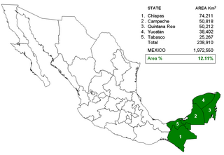
Map of Mexico highlighting the 5 states (Campeche, Chiapas, Quintana Roo, Tabasco and Yucatán) east of the Isthmus of Tehuantepec sometimes considered within Central America by some geographers. Statistics of state area and relative percentage compared with Mexico total area.
Licensing
| This work has been released into the public domain by its author, AlexCovarrubias. This applies worldwide. In some countries this may not be legally possible; if so: |
File history
Click on a date/time to view the file as it appeared at that time.
| Date/Time | Thumbnail | Dimensions | User | Comment | |
|---|---|---|---|---|---|
| current | 05:38, 28 September 2006 | | 943 × 652 (91 KB) | AlexCovarrubias | Map of Mexico highlighting the 5 states (Campeche, Chiapas, Quintana Roo, Tabasco and Yucatán) east of the Isthmus of Tehuantepec sometimes considered within Central America by some geographers. Statistics of state area and re |
File usage
The following pages on the English Wikipedia use this file (pages on other projects are not listed):
Global file usage
The following other wikis use this file:
- Usage on no.wikipedia.org