Size of this preview: 800 × 496 pixels. Other resolutions: 320 × 198 pixels | 640 × 397 pixels | 1,200 × 744 pixels.
Original file (1,200 × 744 pixels, file size: 1.09 MB, MIME type: image/gif, looped, 12 frames, 12 s)
| This is a file from the Wikimedia Commons. Information from its description page there is shown below. Commons is a freely licensed media file repository. You can help. |
| This is a featured picture, which means that members of the community have identified it as one of the finest images on the English Wikipedia, adding significantly to its accompanying article. If you have a different image of similar quality, be sure to upload it using the proper free license tag, add it to a relevant article, and nominate it. |
| This image was selected as picture of the day on the English Wikipedia for October 10, 2010. |
Summary
| Description |
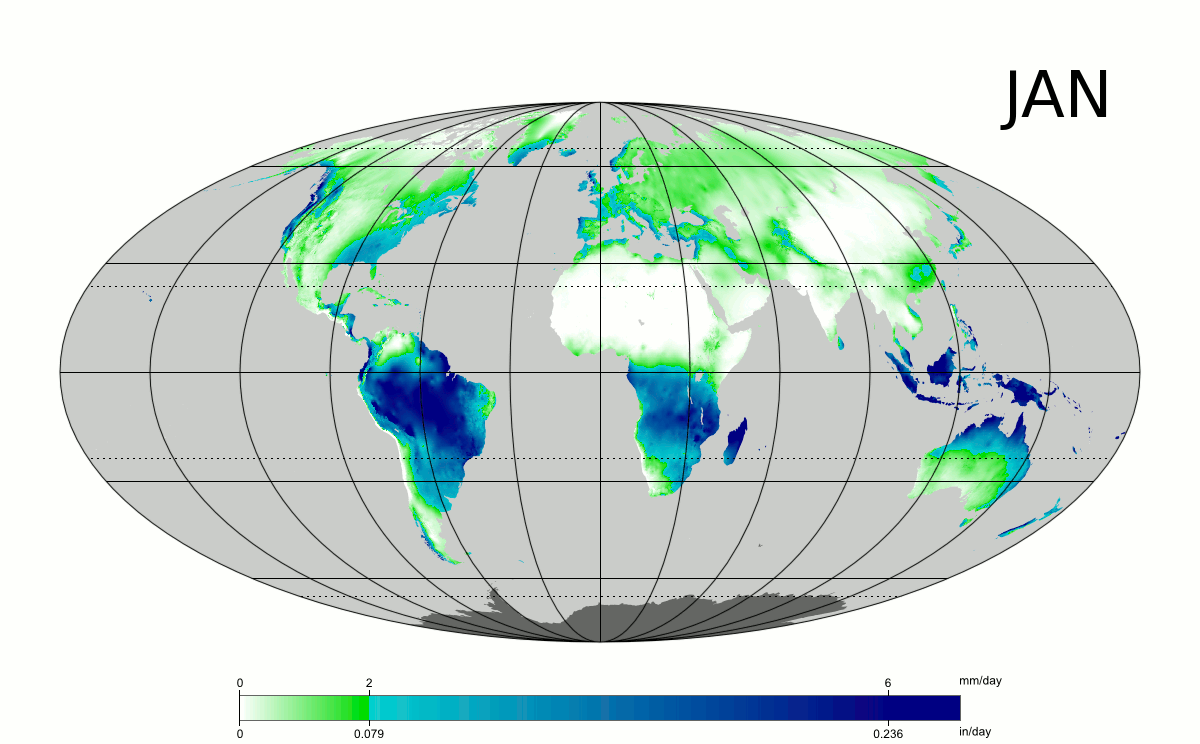
English: Long-term average precipitation by month (mm/day and in/day), based on 1961-1990 data. Animated GIF. Mollweide projection. |
| Date | February-March 2009 |
| Source | Own work by uploader, sources: CRU CL 2.0 (New, M., Lister, D., Hulme, M. and Makin, I., 2002: A high-resolution data set of surface climate over global land areas. Climate Research 21: 1–25) and File:Tissot indicatrix world map Mollweide proj.svg by Eric Gaba. |
| Author | PZmaps |
| Other versions |
Derivative works of this file: |
|
Licensing
I, the copyright holder of this work, hereby publish it under the following licenses:
This file is licensed under the Creative Commons Attribution-Share Alike 3.0 Unported license.
- You are free:
- to share – to copy, distribute and transmit the work
- to remix – to adapt the work
- Under the following conditions:
- attribution – You must give appropriate credit, provide a link to the license, and indicate if changes were made. You may do so in any reasonable manner, but not in any way that suggests the licensor endorses you or your use.
- share alike – If you remix, transform, or build upon the material, you must distribute your contributions under the same or compatible license as the original.

|
Permission is granted to copy, distribute and/or modify this document under the terms of the GNU Free Documentation License, Version 1.2 or any later version published by the Free Software Foundation; with no Invariant Sections, no Front-Cover Texts, and no Back-Cover Texts. A copy of the license is included in the section entitled GNU Free Documentation License. |
You may select the license of your choice.
]
File history
Click on a date/time to view the file as it appeared at that time.
| Date/Time | Thumbnail | Dimensions | User | Comment | |
|---|---|---|---|---|---|
| current | 02:41, 6 March 2010 | | 1,200 × 744 (1.09 MB) | Aiyizo | Optimized animation using GIMP. |
| 19:29, 6 April 2009 |  | 1,200 × 744 (1.48 MB) | PZmaps | higher resolution | |
| 22:00, 25 February 2009 |  | 550 × 340 (450 KB) | PZmaps | {{Information |Description={{en|1=Animated global map of long term mean monthly precipitation (Mollweide projection)}} |Source=Own work by uploader, sources: [http://www.cru.uea.ac.uk/cru/data/hrg.htm CRU CL 2.0] (New, M., Lister, D., Hulme, M. and Makin, |
File usage
The following pages on the English Wikipedia use this file (pages on other projects are not listed):
- Atmospheric circulation
- Climate classification
- Earth rainfall climatology
- List of climate scientists
- Rain
- Talk:Precipitation/Archive 1
- User:FlightTime/Workshop
- User talk:Nergaal/Archive 4
- User talk:PZmaps
- Wikipedia:Featured picture candidates/July-2009
- Wikipedia:Featured picture candidates/MeanMonthlyPrecipitations
- Wikipedia:Featured pictures/Natural phenomena/Weather
- Wikipedia:Featured pictures thumbs/18
- Wikipedia:Wikipedia Signpost/2009-07-27/Features and admins
- Wikipedia:Wikipedia Signpost/2009-07-27/SPV
- Wikipedia:Wikipedia Signpost/Single/2009-07-27
- Template:POTD/2010-10-10
- Template:Portal POTD/testcases
- Portal:Water
- Portal:Weather/Featured content/FP
- Portal:Weather/Featured content/FP/23
- Portal:Weather/Selected article
- Portal:Weather/Selected article/18
Global file usage
The following other wikis use this file:
- Usage on ar.wikipedia.org
- Usage on ast.wikipedia.org
- Usage on az.wikipedia.org
- Usage on ba.wikipedia.org
- Usage on be-tarask.wikipedia.org
- Usage on be.wikipedia.org
- Usage on bn.wikipedia.org
- Usage on ca.wikipedia.org
- Usage on cs.wikipedia.org
- Usage on cv.wikipedia.org
- Usage on da.wikipedia.org
- Usage on da.wikibooks.org
- Usage on de.wikipedia.org
- Usage on diq.wikipedia.org
- Usage on es.wikipedia.org
- Usage on eu.wikipedia.org
- Usage on fa.wikipedia.org
- Usage on fr.wikipedia.org
- Usage on fy.wikipedia.org
- Usage on gl.wikipedia.org
- Usage on gv.wikipedia.org
- Usage on ha.wikipedia.org
- Usage on hi.wikipedia.org
- Usage on ht.wikipedia.org
- Usage on hu.wikipedia.org
- Usage on hy.wikipedia.org
- Usage on id.wikipedia.org
- Usage on it.wikipedia.org
- Usage on it.wikibooks.org
- Usage on ka.wikipedia.org
- Usage on kk.wikipedia.org
- Usage on lmo.wikipedia.org
View more global usage of this file.