File:Massacre of Oradour-sur-Glane.svg

Original file(SVG file, nominally 1,467 × 987 pixels, file size: 180 KB)

Summary

Description
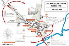
English: Vector version of the French map - Création originale à partir des cartes IGN de Geoportail et des livres de Jean-Jacques Fouché, Oradour., Paris, Liana Levi, 2001, de Guy Pauchou et Pierre Masfrand, Oradour-sur-Glane, vision d'épouvante, Lavauzelle Graphic, Limoges, 1992 et de Philip Vickers, La Division Das Reich de Montauban à la Normandie, Lucien Souny, 2003
Date
Source File:Massacre d'Oradour-sur-Glane2.jpg
Original file: Own work of Rozol 77 - Création originale à partir des cartes IGN de Geoportail et des livres de Jean-Jacques Fouché, Oradour., Paris, Liana Levi, 2001, de Guy Pauchou et Pierre Masfrand, Oradour-sur-Glane, vision d'épouvante, Lavauzelle Graphic, Limoges, 1992 et de Philip Vickers, La Division Das Reich de Montauban à la Normandie, Lucien Souny, 2003
Author Ikonact and User:DutchTreat
Other versions

Licensing

I, the copyright holder of this work, hereby publish it under the following license:
w:en:Creative Commons
attribution share alike
This file is licensed under the Creative Commons Attribution-Share Alike 4.0 International license.
You are free:
  • to share – to copy, distribute and transmit the work
  • to remix – to adapt the work
Under the following conditions:
  • attribution – You must give appropriate credit, provide a link to the license, and indicate if changes were made. You may do so in any reasonable manner, but not in any way that suggests the licensor endorses you or your use.
  • share alike – If you remix, transform, or build upon the material, you must distribute your contributions under the same or compatible license as the original.

Captions

Add a one-line explanation of what this file represents

Items portrayed in this file

depicts

5 July 2021

image/svg+xml

File history

Click on a date/time to view the file as it appeared at that time.

Date/TimeThumbnailDimensionsUserComment
current20:01, 20 August 2021Thumbnail for version as of 20:01, 20 August 20211,467 × 987 (180 KB)Ikonacttext adjustment
07:45, 20 August 2021Thumbnail for version as of 07:45, 20 August 20211,467 × 987 (177 KB)Ikonactfont chnaged to DejaVu
13:52, 16 July 2021Thumbnail for version as of 13:52, 16 July 20211,467 × 987 (171 KB)DutchTreatexpanded to include all text boxes in English
10:01, 6 July 2021Thumbnail for version as of 10:01, 6 July 20211,467 × 987 (629 KB)Ikonactremove black frame
09:58, 6 July 2021Thumbnail for version as of 09:58, 6 July 20211,467 × 987 (629 KB)Ikonact+ background
21:34, 5 July 2021Thumbnail for version as of 21:34, 5 July 20211,467 × 987 (628 KB)Ikonact{{Information |description={{en|1=Vector version of the French map - Création originale à partir des cartes IGN de Geoportail et des livres de Jean-Jacques Fouché, Oradour., Paris, Liana Levi, 2001, de Guy Pauchou et Pierre Masfrand, Oradour-sur-Glane, vision d'épouvante, Lavauzelle Graphic, Limoges, 1992 et de Philip Vickers, La Division Das Reich de Montauban à la Normandie, Lucien Souny, 2003}} |date=2021-07-05 |source=File:Massacre d'Oradour-sur-Glane2.jpg<br/>Original file: {{own}}...
No pages on the English Wikipedia use this file (pages on other projects are not listed).
Metadata