.svg)
.svg&action=edit&redlink=1)

Size of this PNG preview of this SVG file: 512 × 384 pixels. Other resolutions: 320 × 240 pixels | 640 × 480 pixels | 1,024 × 768 pixels | 1,280 × 960 pixels | 2,560 × 1,920 pixels.
Original file (SVG file, nominally 512 × 384 pixels, file size: 389 KB)
| This is a file from the Wikimedia Commons. Information from its description page there is shown below. Commons is a freely licensed media file repository. You can help. |
.svg)
Summary
| Description |
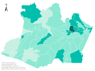
Português: Este mapa demostra os níveis do IDH do Amazonas em 2010.
Legenda: Muito alto
Alto
Médio
Baixo
Muito baixo
English: This map shows the HDI in Amazonas in 2010.
Legend: Very high
High
Medium
Low
Very low |
| Date | |
| Source |
Brazil Amazonas location map.svg: |
| Author | Allice Hunter |
| SVG development | This map was created with Adobe Illustrator. |
Licensing
I, the copyright holder of this work, hereby publish it under the following license:
This file is licensed under the Creative Commons Attribution-Share Alike 4.0 International license.
- You are free:
- to share – to copy, distribute and transmit the work
- to remix – to adapt the work
- Under the following conditions:
- attribution – You must give appropriate credit, provide a link to the license, and indicate if changes were made. You may do so in any reasonable manner, but not in any way that suggests the licensor endorses you or your use.
- share alike – If you remix, transform, or build upon the material, you must distribute your contributions under the same or compatible license as the original.
File history
Click on a date/time to view the file as it appeared at that time.
| Date/Time | Thumbnail | Dimensions | User | Comment | |
|---|---|---|---|---|---|
| current | 04:47, 23 May 2021 | | 512 × 384 (389 KB) | Allice Hunter | New colour scheme and quality adjustments |
| 20:04, 12 July 2019 |  | 512 × 385 (399 KB) | Allice Hunter | Cropped | |
| 02:48, 21 December 2018 |  | 729 × 603 (595 KB) | Allice Hunter | Final version | |
| 06:46, 6 December 2018 |  | 729 × 605 (591 KB) | Allice Hunter | No raster graphics. New map template. Absurd improvement in quality. Addition of information and municipal boundaries. Valid SVG code | |
| 19:02, 6 July 2017 |  | 512 × 359 (289 KB) | Allice Hunter | Cross-wiki upload from pt.wikipedia.org |
File usage
The following pages on the English Wikipedia use this file (pages on other projects are not listed):
Global file usage
The following other wikis use this file:
- Usage on pt.wikipedia.org
.svg)